Korea Hydrographic and Oceanographic Agency to Launch New Service on the 24th
Map Types Simplified from 7 to 3, Navigational Aids Displayed Separately
The Korea Hydrographic and Oceanographic Agency under the Ministry of Oceans and Fisheries has completely overhauled its sea map service for the first time in 10 years. The service has been significantly enhanced in terms of user convenience and accuracy by increasing the maximum zoom level and shortening the update cycle for marine information.
The Korea Hydrographic and Oceanographic Agency announced on the 23rd that, starting on the 24th, it will provide an improved sea map service through the Marine Spatial Information Portal "Gaebanghae" and the marine safety app "Anjunghae." Gaebanghae is a national integrated marine spatial information platform that provides marine spatial planning information and various marine spatial data, while Anjunghae is an app that offers safety information needed for marine activities as well as emergency reporting functions.
The sea map is an online mapping service that provides various information required for marine activities such as yachting, leisure, and small fishing vessels, including water depth, navigational aids, and underwater obstructions. It is a leading marine map platform that is currently linked to and utilized by more than 350 public and private web and mobile applications.
The core of this overhaul is to improve readability and timeliness. First, the zoom levels of the map have been subdivided from the previous 10 levels to 12 levels so that users can view depth information and underwater obstructions more clearly. In addition, the update cycle for marine information such as navigational aids has been changed from a quarterly schedule to an as-needed update system, enabling the latest information to be reflected more quickly.
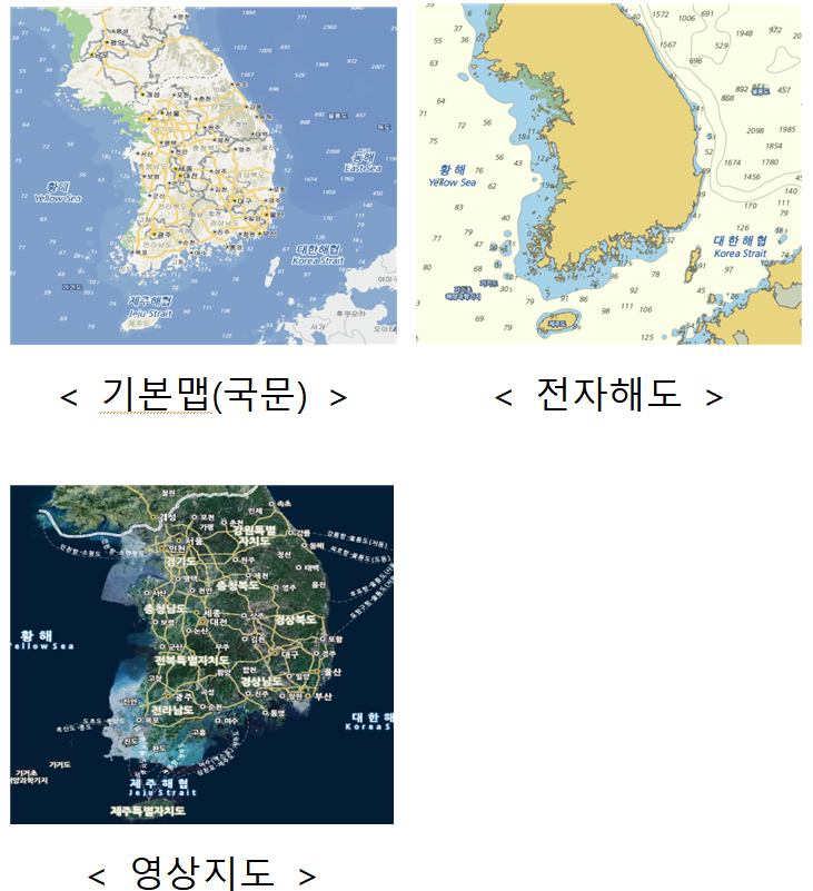
The types of maps have also been greatly simplified. Previously, seven types were provided, including basic (Korean and English), electronic and paper nautical charts, leisure, imagery, and maritime boundaries. Taking into account usage frequency and practicality, these have been consolidated into three types: basic (Korean), electronic charts, and imagery maps. This allows users to quickly find the information they need on a more intuitive screen.
In particular, the change in how navigational aids are displayed stands out. Previously, navigational aids were inserted directly into the map, but there had been criticism that this reduced readability because their positions change frequently and they are widely distributed across all Korean waters. After the overhaul, navigational aids are displayed as separate object icons to improve map visibility and to enable faster information updates.
Jung Kyusam, Administrator of the Korea Hydrographic and Oceanographic Agency, said, "This overhaul focused on improving readability and convenience by reflecting users' actual usage environments," adding, "We will continue to provide the latest marine information quickly and accurately so that the public can use the sea more safely, and we will keep improving related services on an ongoing basis."
© The Asia Business Daily(www.asiae.co.kr). All rights reserved.
![Clutching a Stolen Dior Bag, Saying "I Hate Being Poor but Real"... The Grotesque Con of a "Human Knockoff" [Slate]](https://cwcontent.asiae.co.kr/asiaresize/183/2026021902243444107_1771435474.jpg)


