Proving Administrative Excellence with Four Major Awards
Accelerating Citizen-Centered Innovation with the Spirit of "Junma Leap"
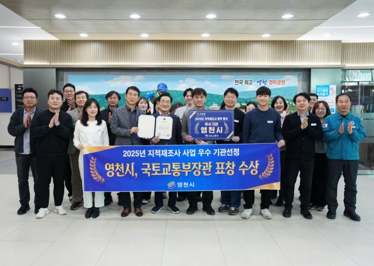
Yeongcheon City (Mayor Choi Kimoon) is emerging as a national leader in cadastral administration, protecting citizens' property rights and enhancing urban competitiveness through advanced cadastral administration that incorporates digital technology.
The city announced plans to fully implement field-oriented communication and advanced, digital-based land administration in 2026, inspired by the spirit of "Junma Leap" (leaping forward vigorously like a horse into a new era).
◆Administrative Excellence Proven by Award-Winning Achievements
The Cadastral Information Division of Yeongcheon City has established itself as a leading city in the field of cadastral administration, achieving consecutive results in various evaluations and competitions hosted by the Ministry of Land, Infrastructure and Transport and Gyeongsangbuk-do in 2024 and 2025.
From the protection of citizens' property rights to the establishment of digital national land information, the city's field-oriented cadastral administration has been highly praised externally, earning the distinction of winning four major awards and proving its top-level administrative capabilities in the province.
First, the city was recognized as an outstanding local government in the cadastral resurvey project evaluation hosted by the Ministry of Land, Infrastructure and Transport, officially acknowledging its achievements in resolving land boundary disputes and protecting property rights.
Yeongcheon City has been highly evaluated for its efforts to minimize conflicts during the implementation of the national core project to convert paper cadastral maps from the Japanese colonial era into digital cadastral maps. By strengthening resident briefings and on-site communication, and ensuring accurate survey results, the city has stably promoted citizen-centered cadastral resurvey projects.
Additionally, in the Gyeongsangbuk-do Cadastral Administration Comprehensive Evaluation, the city won the top prize last year and the newly established grand prize this year, further demonstrating its balanced administrative capabilities across all areas of cadastral work, including the implementation of new special policies, discovery of exemplary cases, prompt and accurate land movement processing, and high-quality civil service response.
Furthermore, at the Gyeongsangbuk-do Cadastral Survey Competition, the city was recognized for its outstanding surveying technology and equipment operation skills, winning the excellence award in 2025 and achieving six consecutive wins.
Accurate surveying technology and on-site response capabilities are the foundation of cadastral administration, and practical, field-oriented competencies have consistently led to significant achievements.
At the Gyeongsangbuk-do "Cadastral Work Research Project Presentation," the city proposed solutions to boundary discrepancies in administrative district border areas, winning the encouragement award and striving to enhance the reliability and efficiency of cadastral administration.
◆Citizen-Centered Cadastral Administration for Greater Convenience
Last year, as a special initiative in the cadastral field, Yeongcheon City, in cooperation with the Yeongcheon branch of the Korea Land and Geospatial Informatix Corporation, established the province's first "Cadastral Survey Boundary Information QR Code System." By marking QR codes on the survey result maps issued after cadastral surveys, any citizen can easily and quickly check land boundary information (survey result maps, site photos, and the locations of boundary points in three directions) using a smartphone.
This has significantly reduced the time and cost for landowners to request re-surveys and has greatly contributed to the prevention of boundary disputes.
Additionally, by linking with the integrated real estate information system and the Toji-eum website, the city has enabled citizens to access a wide range of public information, including land use plans, individual official land prices, and building registers.
The "On-Site Cadastral Civil Service Program," operated annually for residents with limited mobility or inconvenient transportation, continues to receive a positive response.
Through collaboration among cadastral, farmland, tax, and the Yeongcheon branch of the Korea Land and Geospatial Informatix Corporation, the city directly handles cadastral and various civil matters on-site. Last year, the city visited 23 times and resolved 311 civil complaints.
This year, the city plans to visit 10 administrative welfare centers and 12 towns and villages three to four times per month, accepting and consulting on civil complaints closely related to residents' daily lives and property rights on-site, thereby alleviating inconveniences and providing administration that residents can truly experience.
The city also conducts annual comprehensive surveys of 4,023 surveying control points installed to improve surveying accuracy.
Surveying control points serve as the foundation for various development projects, provide accurate location data, and are the standard for spatial information. If lost or damaged, they can cause survey delays and land boundary disputes. Yeongcheon City promptly restores or removes any problematic control points, preventing disputes in advance and systematically managing these points to enhance the reliability of cadastral administration.
This year, the city was selected for the 2025 "Cadastral Records Land Category Realignment" contest project, securing full national funding to comprehensively investigate and align discrepancies between cadastral records and actual land use, thereby contributing to the protection of citizens' property rights.
In addition, to improve access to cadastral civil services and address difficulties in completing application forms, the city will produce "Cadastral Civil Service QR Code Guides."
Through QR codes, citizens can easily view and download 20 types of application forms and sample documents, greatly enhancing convenience and access to information.
◆Setting a New Standard for Land Administration with Digital Technology
The city was selected for the Ministry of Land, Infrastructure and Transport's national project to build high-precision electronic maps for two consecutive years in 2024 and 2025, securing approximately 2.1 billion won in national funding to establish three-dimensional spatial information for urban areas of Yeongcheon.
This project, funded equally by national and local governments, completed its first phase in September last year, building high-precision electronic maps for urban areas in the city's eastern region. The second phase, targeting town and township urban areas, began in September last year and is scheduled for completion in April.
The high-precision electronic maps to be built through this project will include large-scale (1:1000) digital topographic maps, aerial imagery, three-dimensional road registers, and 3D building models. These will serve as the foundation for smart city development and will be integrated with administrative information to provide a variety of services in urban planning, transportation, and disaster response.
The city will also continue its digital project to fully convert old land and forest registers, originally recorded in Japanese era notation and Chinese characters during the Japanese colonial period, into Korean. This project involves precisely scanning approximately 300,000 old land and forest registers into high-resolution color images, then converting all records, including land descriptions and ownership details, into Korean and building a digital database.
Last year, the city completed the project for 80,000 old land registers, including those in the eastern region, and this year plans to process an additional 76,000 registers.
This Koreanization project is expected to greatly improve the convenience of civil services and the efficiency of administrative processing by enabling fast and accurate data searches and handling of civil complaints.
◆Protecting Citizen Safety Through Address Information
Address information policy is directly linked to citizen safety.
Yeongcheon City strives to create a safe urban environment and maintain citizen safety by implementing various address information policies every year.
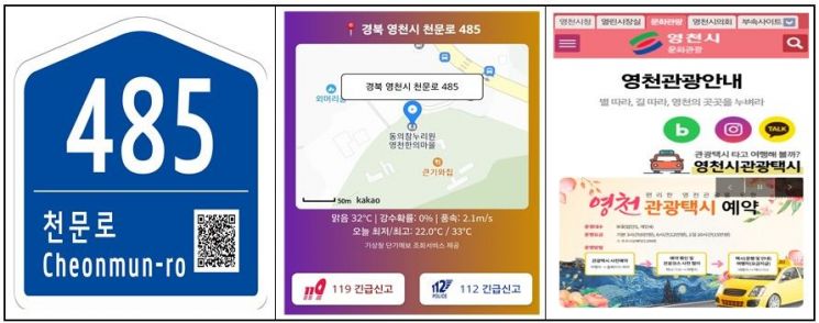
The city conducts comprehensive surveys of address information facilities such as road name signs and building number plates, installing new facilities where needed and replacing lost or damaged ones.
In particular, newly installed or replaced building number plates are equipped with QR codes to enable precise location information to be provided to emergency services (112 and 119) in urgent situations.
For national point number plates, which are crucial for providing accurate location information in mountainous, coastal, and island areas where location confirmation is difficult, the city conducts annual surveys. This year, with provincial funding, the city plans to install 20 new national point number plates along the hiking trail from Sudosa Temple in Chisan-ri, Sinnyeong-myeon to Dongbong Peak of Palgongsan Mountain, where the number of hikers is increasing and safety concerns are rising.
Since 2022, the city has steadily implemented the installation of nighttime lighting devices on road name signs to enhance citizen safety, completing installations at 169 dark alleys without streetlights and planning to add 25 more locations this year.
This year, the city will also produce and install object address plates with QR codes for various multi-use facilities and locations without buildings, such as bus stops, parks, heat shelters, public parking lots, and earthquake evacuation sites, to provide accurate location information.
By the end of last year, a total of 1,014 object address plates had been installed, and this year, with provincial funding, the city plans to install an additional 250 plates.
Through the maintenance and new installation of various address information facilities, the city aims to support prompt and accurate dispatch of emergency services such as fire and police in emergencies, while also striving to create a safer urban environment and prevent crime.
◆Establishing a Reliable Real Estate Transaction Order Through Accurate Information
In Yeongcheon City, the number of real estate transaction reports in the previous year was 7,756, a 4.8% decrease compared to 2024. Along with a decline in transaction amounts and continued economic stagnation, transaction volume has been decreasing since 2022.
To address the lack of awareness regarding development charges imposed after the completion of development projects, the city proactively promotes the development charge system through advance notifications to target projects and the production and distribution of informational leaflets.
Last year, the city notified and imposed development charges on 296 projects after approval or completion, collecting a total of 213 million won in development charges. This contributed to preventing land speculation, promoting efficient land use, and expanding national finances by recouping and distributing land profits.
In addition, the standard land price for 2026 saw a slight nationwide increase due to the freeze in the realization rate.
For Yeongcheon City, the standard land price is expected to rise by 1.42% compared to the previous year (compared to 3.59% nationwide and 1.16% in Gyeongbuk), reflecting the impact of large-scale national projects and regional development, such as the extension of Daegu Metro Line 1 to Yeongcheon (Kumho), Yeongcheon Racecourse, and the Yeongcheon High-Tech Park District, which is scheduled for completion in the first half of this year.
The standard land price, to be announced at the end of April, will affect the individual official land prices of 258,900 parcels, which will in turn be reflected in various taxes such as property tax and comprehensive real estate tax on land and housing.
For citizens who have difficulty using the internet or are too busy to check individual official land prices, the city operates an "Individual Official Land Price SMS Notification Service." This service not only provides information on land prices but also sends reminders about the submission of opinions and objection periods, enhancing citizens' right to know and protecting their property rights.
To establish a reliable real estate transaction order, the city is committed to protecting citizens' right to know and property rights through the management of actual transaction reports, one-stop registration for real estate agencies, advance notification and guidance on development charges, and the individual official land price SMS notification service.
Starting in January of the new year, the city will implement the "Brokerage Fee Support Project for Housing-Vulnerable Groups" to alleviate the economic burden on vulnerable residents and create a stable residential environment.
The support targets are basic livelihood security recipients and low-income households who have purchased or rented homes for less than 100 million won, providing up to 300,000 won in brokerage fee support (100% provincial funding).
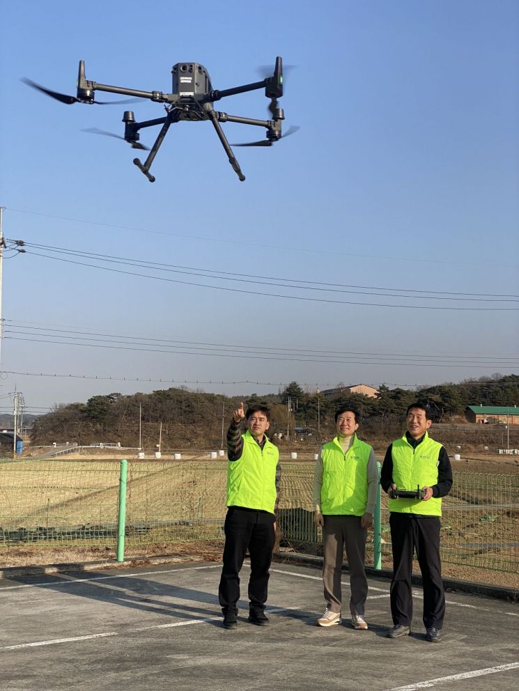
◆Completing Cadastral Resurvey with Drones, Realizing Dispute-Free Land Boundaries
Yeongcheon City is using drones to produce orthoimages during the cadastral resurvey project, enabling more precise implementation of land boundaries.
Drone orthoimages play a significant role in enhancing visual understanding during boundary consultations, earning residents' trust and helping prevent land boundary disputes in advance.
The cadastral resurvey project, a national project fully funded by the central government and scheduled to run until 2030, has completed work on 23 districts, 6,489 parcels, and 4,938,714 square meters since the enactment of the "Special Act on Cadastral Resurvey" in 2012, starting with the Imgoseonwon District.
In December of last year, the city completed projects in four districts (1,220 parcels), including Kumho Bongjuk District, and is currently working on four more districts (1,116 parcels), including Hwabuk Sangsong District.
Notably, from February 2025, Yeongcheon City became the first in Gyeongbuk Province to accept electronic applications for consent to designate cadastral resurvey districts using self-produced smartphone QR codes, significantly improving convenience for applicants and administrative efficiency.
This year, the city has designated Hwabuk Osan District and Hwanam Daecheon District (1,176 parcels, 1,059,937 square meters) as new project sites and plans to continue the cadastral resurvey project sequentially through 2027.
Furthermore, for the completed Munnaeoe District, the city will produce and attach "My Home Boundary Check QR Code" signs to buildings, enabling citizens to easily verify land boundaries and providing high-quality cadastral information services.
In this way, Yeongcheon City is striving to lead advanced administration by expanding the cadastral resurvey project, responding to changing demands for cadastral information driven by technological advancement, implementing digital cadastral information, and conducting precise surveys and investigations of all land to resolve boundary disputes and protect citizens' property rights.
Going forward, the city plans to further expand the cadastral resurvey project, upgrade administrative services based on spatial information, and build a one-stop land administration service through interdepartmental cooperation, thereby integrating cadastral administration more deeply into citizens' daily lives.
A city official stated, "Cadastral administration is a core administrative function directly linked to citizens' property rights," adding, "Through the construction of smart spatial information and the cadastral resurvey project, we will realize citizen-centered communication administration and support Yeongcheon's new leap forward."
Yeongcheon City's cadastral administration, which combines digital technology and field-oriented administration, is now becoming more than just an administrative service-it is a key driver in protecting citizens' property rights and shaping the city's future.
© The Asia Business Daily(www.asiae.co.kr). All rights reserved.
![Clutching a Stolen Dior Bag, Saying "I Hate Being Poor but Real"... The Grotesque Con of a "Human Knockoff" [Slate]](https://cwcontent.asiae.co.kr/asiaresize/183/2026021902243444107_1771435474.jpg)


