The Korea Forestry Promotion Institute announced on December 18 that it will pilot the application and introduction of helicopter-based LiDAR (Light Detection and Ranging) technology for monitoring pine wilt disease.
The LiDAR monitoring survey involves mounting LiDAR equipment on a helicopter, emitting laser pulses into the forest, and analyzing the reflected signals and distance information that return after passing through the forest canopy.
Through this process, the institute aims to obtain three-dimensional structural information of forests, such as tree height and canopy structure, and to verify the feasibility of analyzing the distribution of dead trees.
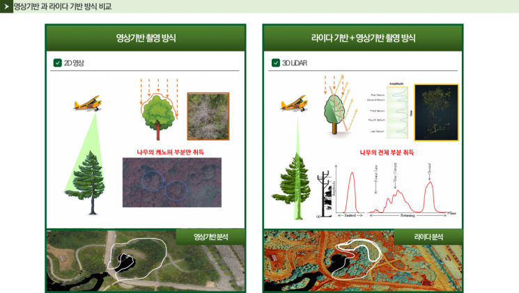 Comparison Data of Video-Based and LiDAR-Based Methods. Provided by Korea Forestry Promotion Institute
Previously, video-based methods using unmanned aerial vehicles (drones) were primarily used for pine wilt disease monitoring. However, these methods were limited by the restricted area that could be surveyed.
In contrast, helicopter-based LiDAR monitoring can survey vast forest areas in a short period of time, making it potentially effective for large-scale forest regions. The pilot introduction is intended to assess whether these advantages can be realized in practice.
The LiDAR monitoring survey targets a 5-kilometer radius of forest where dead trees affected by pine wilt disease are distributed. In particular, during the pilot phase, the institute plans to analyze suspected areas of dead trees using the reflection intensity of laser pulses and tree structure information, and to comprehensively review the technical feasibility and limitations by comparing and analyzing these results with those from existing video-based monitoring.
After the pilot survey, the institute will review the potential for role-sharing between drone-based and helicopter-based LiDAR monitoring, and plans to secure foundational data to enable the selection of the most appropriate monitoring method based on the area and characteristics of future target sites.
Kim Yonghun, Head of the Southern Survey Office, stated, "The helicopter-based LiDAR monitoring survey is a stage for confirming new technological possibilities in large-scale forest monitoring," adding, "Based on this process, we will continue to accumulate foundational data to establish a scientific and systematic forest monitoring system."
© The Asia Business Daily(www.asiae.co.kr). All rights reserved.
![Clutching a Stolen Dior Bag, Saying "I Hate Being Poor but Real"... The Grotesque Con of a "Human Knockoff" [Slate]](https://cwcontent.asiae.co.kr/asiaresize/183/2026021902243444107_1771435474.jpg)


