Utilized for Ocean and Land Change Analysis
Available Free of Charge on KISTI’s National Research Data Platform
The Space Aviation Agency has released approximately 150,000 entries of the "2025 Satellite Information Big Data AI Training Dataset" based on national satellite data. This dataset was built with a focus on ocean monitoring and land cover change detection.
The Korea Aerospace Research Institute, the lead organization for the "Satellite Information Big Data Utilization Support System Development Project," was responsible for building the dataset. Since 2023, the Space Aviation Agency has systematically released over 630,000 satellite data entries for AI training. With this additional release, the scope of use for both industry and academia is expected to expand further.
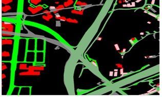
Land cover change analysis photos captured and analyzed by Multipurpose Practical Satellites 3 and 3A. By recording multi-temporal images of the same area, it can be used to precisely analyze long-term land use changes such as urban expansion, forest destruction, and farmland changes. Provided by the Space Agency
The released data is based on imagery from Multipurpose Practical Satellites 3, 3A, and 5, and consists of six ocean monitoring datasets-fish farms, oil spills, coastlines, vessels, landfast ice, and sea ice-as well as a land cover time-series change dataset. These resources can be used for monitoring illegal oil discharges, analyzing coastal erosion, and studying environmental changes such as urban expansion and forest destruction.
In addition, the Space Aviation Agency has released a variety of other datasets, including object detection (880,000 images), building segmentation (350,000 images), roads (over 10,000 km), cloud detection (7,500 images), and land cover classification (1,200 images).
All materials are available free of charge on the National Research Data Platform (DataOn) operated by the Korea Institute of Science and Technology Information (KISTI).
Han Changheon, Director of the Space Aviation Industry Bureau, stated, "AI training data utilizing national satellite imagery will become a key infrastructure to enhance usability for domestic researchers and industry. We will continue to expand the scope of public data to reflect new demands."
© The Asia Business Daily(www.asiae.co.kr). All rights reserved.
![Clutching a Stolen Dior Bag, Saying "I Hate Being Poor but Real"... The Grotesque Con of a "Human Knockoff" [Slate]](https://cwcontent.asiae.co.kr/asiaresize/183/2026021902243444107_1771435474.jpg)


