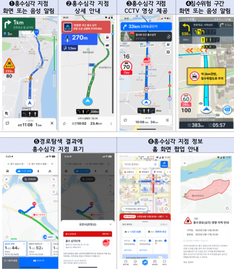
On June 30, the government and major navigation service providers announced that they would strengthen the provision of road hazard information related to floods via navigation systems ahead of the upcoming heavy rain. This service helps drivers recognize dangerous situations and drive with caution by providing alerts on the navigation screen and through voice guidance when a vehicle approaches areas at risk of flooding or inundation.
This year, information for the "Severe Flood Alert" stage will be newly provided at 933 locations nationwide. This stage refers to areas that have reached 100% flood volume and are at imminent risk of river overflow. However, the navigation systems will not provide alternative detour routes. In addition, for the Yeongnam region, which is particularly vulnerable to flood damage, six underground roads at risk of inundation and seven general roads at risk of flooding will be included in the guidance. These sections are linked to the Korea Meteorological Administration's heavy rain advisories, so real-time hazard information will be provided when the advisories are in effect.
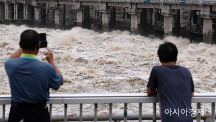 Due to the influence of the monsoon front, continuous heavy rain has persisted for five days. On August 2020, at Paldang Dam in Hanam, Gyeonggi Province, 12 out of 15 sluice gates were opened, releasing approximately 18,000 tons of water per second. The increased flow from Paldang Dam since the morning affected the Han River, leading to a flood warning being issued for Hangang Bridge at 11 a.m. Photo by Hyunmin Kim kimhyun81@
Until now, flood warnings were provided at 223 locations nationwide, including discharge information for 37 dams, when flood volume was expected to reach 70%. This year, the number of locations where information is provided has increased by approximately four times, and high-risk sections immediately before river overflow will also be guided in real time, making it possible to identify risks more precisely and promptly.
Tmap began offering this service during the current monsoon season, starting on June 26. Other major navigation services such as KakaoNavi, Hyundai Motor, Kia, Naver Map, iNavi Air, and Atlan are scheduled to launch the service sequentially, either by the end of this month or early next month at the latest. The enhancement of flood risk information in these services was made possible by close cooperation between the government and the private sector. The Ministry of Science and ICT and the National Information Society Agency (NIA) integrated flood risk information, which had previously been distributed across various agencies, into a standardized application programming interface (API) for unified provision.
A government official stated, "We will continue to combine the government's capabilities with companies' digital services to ensure the safety and security of the public, leaving no gaps, and strive to build a safer Korea." The official added, "In particular, the guidance for underground roads and general roads at risk of flooding, which was launched this year exclusively in the Yeongnam region, will be considered for nationwide expansion in the future depending on its effectiveness."
© The Asia Business Daily(www.asiae.co.kr). All rights reserved.
![Clutching a Stolen Dior Bag, Saying "I Hate Being Poor but Real"... The Grotesque Con of a "Human Knockoff" [Slate]](https://cwcontent.asiae.co.kr/asiaresize/183/2026021902243444107_1771435474.jpg)


