Expected to pass through the Korean Peninsula with 'record-breaking' intensity between the 5th and 6th
Central Disaster and Safety Countermeasures Headquarters immediately raises emergency duty from level 1 to 3
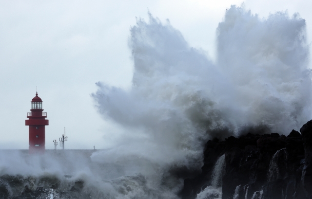 On the 4th, as Typhoon Hinnamnor moves northward toward the Korean Peninsula, waves are crashing along the coast of Seogwipo, Jeju Island.
 [Image source=Yonhap News]
[Asia Economy Reporter Han Seung-gon] Typhoon No. 11 'Hinnamnor' is approaching with an unprecedented scale, causing nationwide tension. 'Hinnamnor' is expected to be more powerful than past typhoons that caused significant damage, such as 'Rusa' and 'Maemi,' raising concerns about widespread damage across the country. Flooding has already occurred in the western region of Jeju. In Busan, residents in flood-prone areas are evacuating proactively.
According to local governments nationwide on the 4th, around noon, Seogwipo City, Daejeong-eup in Jeju Island experienced heavy rain of 74.5 mm per hour due to the indirect influence of Hinnamnor. As a result, about 40 cases of damage, including flooding of houses and commercial buildings in Daejeong-eup, were reported as of 4 p.m. Particularly, on the 5th, when Jeju Island will be directly affected by Hinnamnor, and in the early morning of the 6th, when the typhoon is expected to be closest, very strong rain and wind are anticipated, raising concerns about severe damage.
Haeundae-gu in Busan issued an evacuation advisory starting at 6 p.m. on the 5th for residents of Marine City, Cheongsapo, Mipo, and Gudeokpo, areas with high risk of coastal flooding. Additionally, five sea bridges, including Noryang Bridge, will restrict traffic if the average wind speed exceeds 25 meters per second for 10 minutes.
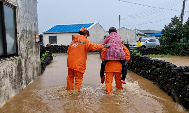 Typhoon No. 11 'Hinnamnor' is moving northward on the 4th, flooding a residential area in Yeongnak-ri, Daejeong-eup, Seogwipo-si, Jeju, where firefighters are rescuing residents. Heavy rain has already begun in Jeju, with cumulative rainfall expected until the 6th.
 [Image source=Yonhap News]
◆ Typhoon 'Hinnamnor' Expected to Be Stronger Than 'Maemi'... What Were the Past Typhoon Damages?
According to the Korea Meteorological Administration's forecast, Hinnamnor is expected to be more powerful than the strongest typhoon to have landed in Korea, 'Sarah' in 1959, and the second strongest, 'Maemi' in 2003.
The deadliest typhoon in terms of human casualties was Typhoon Sarah in 1959, which caused 849 deaths and missing persons. Typhoon 'Betty' in 1972 also flooded Seoul and the central region, resulting in 550 casualties nationwide.
Damage from Typhoon 'Selma' in 1987 was similar, causing 390 billion won in damages, including flooded farmland, and 343 casualties.
In the 2000s, Typhoon 'Rusa' (2002) caused 246 deaths and missing persons, while Typhoon Maemi in 2003 resulted in 119 deaths and 12 missing persons, with 61,844 displaced people. Property damage amounted to 4.2225 trillion won. Maemi recorded the highest instantaneous maximum wind speed among typhoons with a central pressure of 965 hPa and maximum wind speed of 60 meters per second. Following that, Typhoon 'Megi' in 2004 caused 4,712 displaced people and 250 billion won in property damage. Also, during Typhoon 'Chaba' in 2016, six people died and 6,714 were displaced, with property damage of 215 billion won.
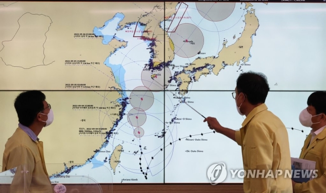 On the morning of the 4th, at the Busan Regional Office of Oceans and Fisheries, Minister Cho Seung-hwan of the Ministry of Oceans and Fisheries and ministry staff were busy checking the preparedness status for Typhoon Hinnamnor, the 11th typhoon, including its trajectory and safety management of ports, ships, and fisheries facilities during the marine and fisheries sector preparedness meeting.
 [Image source=Yonhap News]
◆ "Highest Level Response Activated" Government Strives to Minimize Hinnamnor Damage
The expected path of Typhoon Hinnamnor, which is forecasted to make landfall on the Korean Peninsula on the morning of the 6th, is very similar to that of Typhoon Maemi. The Korea Meteorological Administration announced on the 4th, "Typhoon No. 11 Hinnamnor is expected to make landfall near Tongyeong, Gyeongnam, around 8 a.m. on the 6th, move northeast through the Yeongnam region, and exit into the East Sea around 3 p.m. the same day."
They added, "Although the minimum central pressure is expected to drop from 'very strong' to 'strong' at landfall with 950 hPa, the Yeongnam coastal areas will experience maximum wind speeds of 40 to 60 meters per second and rainfall around 400 mm, so special caution is required."
Meanwhile, the Ministry of the Interior and Safety (MOIS) immediately raised the Central Disaster and Safety Countermeasure Headquarters (CDSCH) emergency duty level from Level 1 to Level 3 on the 4th, due to concerns that Typhoon Hinnamnor will cause nationwide damage greater than past typhoons 'Rusa' and 'Maemi.' This is the first time in the past five years that the emergency level was raised directly to Level 3 for a typhoon.
Additionally, MOIS strongly recommended adjusting working hours in the private sector, as the typhoon is expected to make landfall on Tuesday morning. Schools at all levels were also requested to actively implement school closures or remote classes at the discretion of school principals.
Lee Sang-min, head of the CDSCH, stated, "As the CDSCH is elevated to Level 3, local governments and related public institutions will also activate the highest level of response. While government and related agencies' efforts are important, it is also crucial for citizens to protect their own safety."
© The Asia Business Daily(www.asiae.co.kr). All rights reserved.


