Gyeonggi Province is moving forward with a cadastral re-survey project using drones.
On August 6, Gyeonggi Province announced that it will conduct a drone-based cadastral re-survey for more than 80 locations, including the target districts for next year's project and those applied for by cities and counties over the past two years (2024-2025).
The cadastral re-survey project is a national initiative to convert paper cadastral maps, which were created over a hundred years ago during the Japanese colonial period, into digital cadastral records. The project aims to resolve boundary disputes between neighbors, secure road access for landlocked parcels, and maximize land utilization value, thereby protecting the property rights of residents.
Previously, Gyeonggi Province used drones only for two-dimensional imaging in cadastral re-survey projects. This time, for the first time, the province will acquire three-dimensional imagery.
Traditional drone-based cadastral re-surveys relied on simple aerial photography, producing primarily two-dimensional images. This made it difficult to identify elevation changes and the three-dimensional shapes of structures, necessitating on-site investigations and additional measurements.
However, by utilizing three-dimensional imagery, it is now possible to view the actual terrain and buildings in three dimensions. This significantly streamlines surveying and on-site investigation tasks, resulting in reduced manpower and budget savings.
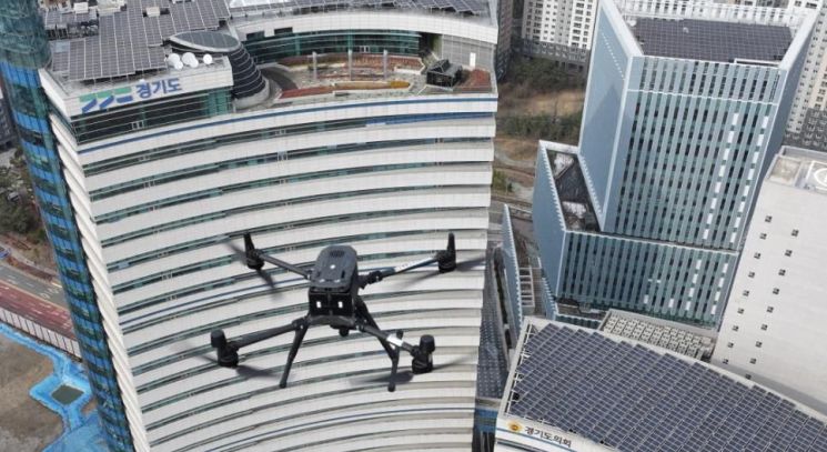 Gyeonggi Province is conducting a cadastral re-survey of the area surrounding the Gyeonggi Provincial Government Office using 3D drones. Photo by Gyeonggi Province
In particular, the use of three-dimensional imagery not only improves work efficiency, but also offers advantages for future administration and industry, such as national land digitalization, digital twins (virtual representations of systems or objects designed to accurately reflect physical entities), and smart cities.
Gyeonggi Province plans to provide three-dimensional imagery to all 31 cities and counties in the province, as well as to the Korea Land and Geospatial Informatix Corporation (LX Corporation) and the Gyeonggi Real Estate Portal (for administrative use), in order to enhance information sharing among administrative agencies and improve the efficiency of spatial information management.
Last month, Gyeonggi Province selected the Suchon 1 District in Hwaseong City as a testbed and piloted the use of drone-based three-dimensional imagery there.
Son Imseong, Director General of Urban Housing at Gyeonggi Province, stated, "Three-dimensional cadastral re-surveys using drones will make it possible to obtain accurate and reliable cadastral information. This will play a major role not only in protecting residents' property rights, but also in the digital transformation of administration. Going forward, Gyeonggi Province will continue to lay a solid foundation for a future-oriented cadastral system."
Since the launch of the eighth popularly elected administration, Gyeonggi Province has carried out cadastral re-survey projects in a total of 281 districts (66,389 parcels, 42 square kilometers). The new three-dimensional imagery will serve as a core foundation for key administrative procedures such as land status surveys, boundary setting, and results verification.
Meanwhile, Gyeonggi Province plans to use the cadastral re-survey process to improve the overall reliability and speed of the project. Specifically, the province will use the imagery to assess current conditions when designating project districts, to help residents visually understand information during public briefings and boundary consultations, and to provide accurate verification data during the results verification stage.
© The Asia Business Daily(www.asiae.co.kr). All rights reserved.
![Clutching a Stolen Dior Bag, Saying "I Hate Being Poor but Real"... The Grotesque Con of a "Human Knockoff" [Slate]](https://cwcontent.asiae.co.kr/asiaresize/183/2026021902243444107_1771435474.jpg)


