Dam Water Levels Rise Due to Torrential Rains, Submerging Site for First Time in Two Years
Sluice Gate Installation Planned, But Completion Expected in Five Years
The Bangudae Petroglyphs in Ulju-gun, Ulsan, which were recently inscribed as a UNESCO World Heritage Site, were submerged just one week after their listing. The Bangudae Petroglyphs are one of the "Petroglyphs of Bangudae Stream," which became the 17th Korean entry on the World Heritage list on July 12. The site is highly regarded for condensing traces from Korea's prehistoric era to the Silla period?such as whale hunting, archery, abstract patterns, and Silla-era inscriptions?into a single location.
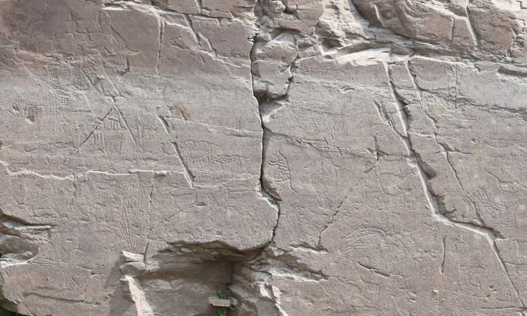
According to the Water Information Portal operated by the Korea Water Resources Corporation as of 9 a.m. on July 19, the water level at Sayeon Dam in Ulju-gun was recorded at 56.19 meters. As a result, a significant portion of the Bangudae Petroglyphs, which measure approximately 8 meters wide and 4.5 meters high (based on the main rock face), became submerged. Sayeon Dam is located about 4.5 kilometers upstream from the petroglyphs along the Daegokcheon Stream. Since it is a natural overflow-type dam with no sluice gates for water level control, heavy rainfall causes the reservoir to fill up, directly affecting the upstream petroglyphs. The dam's full water level is at an elevation of 60 meters above sea level, while the petroglyphs are situated between 53 and 57 meters.
Recently, localized torrential rains have been concentrated in the Ulju-gun area. Heavy rainfall was recorded as follows: 117.8 mm on July 13, 59 mm on July 14, and 123.2 mm on July 17. Due to this, the water level, which was 46.96 meters on July 12, rapidly rose to 49.48 meters by July 15. Although the water level appeared to decrease slightly as the rain subsided, more than 100 mm of rain fell over two days starting July 18, resulting in the submergence of the petroglyphs.
Normally, the Korea Water Resources Corporation consistently releases domestic water from Sayeon Dam to the Cheonsang Water Purification Plant to maintain a low water level, and releases additional industrial water when rain is forecast. However, when such a large amount of rain falls at once, the inflow into the dam far exceeds the outflow, inevitably causing the water level to remain high. With more than 50 mm of additional rain forecast through the afternoon of July 19, the dam's water level is expected to continue rising, and it may take a considerable amount of time for the level to drop again. Until then, the Bangudae Petroglyphs, a World Heritage Site, will remain submerged.
Before this recent flooding, the Bangudae Petroglyphs were submerged for a total of 74 days from August 10 to October 22, 2023, due to monsoon rains and typhoons. From 2014 to 2023, the petroglyphs were submerged for an average of 42 days per year. Before the Korea Water Resources Corporation began actively managing the water level, from 2005 to 2013, the average annual submersion period was 151 days.
In 2021, a plan was established to fundamentally resolve the flooding issue, which leads to damage to the petroglyphs, by installing sluice gates on the dam's spillway (an auxiliary channel that releases excess water when the dam exceeds a certain level). Installing three sluice gates, each 15 meters wide and 7.3 meters high, would allow the dam's water level to be maintained at 52 meters, below the level of the petroglyphs. If all procedures proceed smoothly and construction begins in the second half of next year, completion is expected around 2030. However, there are concerns that if heavy rains occur again before then, repeated flooding could cause even more severe damage to the petroglyphs, and calls are growing for stronger preservation measures.
Meanwhile, Ulsan experienced a series of flood damages due to the heavy rain. In the Bancheon-ri area of Eonyang-eup, Ulju-gun, some roads were completely submerged, and about 10 parked vehicles were flooded up to their roofs. In a residential warehouse on Gomjae 1-gil, Eonyang, Ulju-gun, soil flowed in, prompting the county to dispatch crews for cleanup. At Eunwolam in Beomseo, Ulju-gun, a landslide injured a woman, who was transported to the hospital.
Flood advisories were issued for Taehwa Bridge on the Taehwa River and Beonyeong Bridge on the Dongcheon in Jung-gu, while a flood warning was issued for Sayeon Bridge upstream on the Taehwa River. Ulsan City activated emergency response level 2 at 3:50 a.m. on this day, with over 200 personnel from the city and district/county offices mobilized for emergency duty.
© The Asia Business Daily(www.asiae.co.kr). All rights reserved.
![Clutching a Stolen Dior Bag, Saying "I Hate Being Poor but Real"... The Grotesque Con of a "Human Knockoff" [Slate]](https://cwcontent.asiae.co.kr/asiaresize/183/2026021902243444107_1771435474.jpg)


