End of Monsoon in Jeju and Southern Regions
Heatwave and Tropical Nights Expected to Continue
Precautions Needed Against Heat-related Illnesses
This year's monsoon season ended so quickly that it ranks among the shortest on record. With the monsoon now completely over in Jeju and the southern regions, a nationwide heatwave and tropical nights are expected to intensify.
◆Unusual Expansion of the North Pacific High
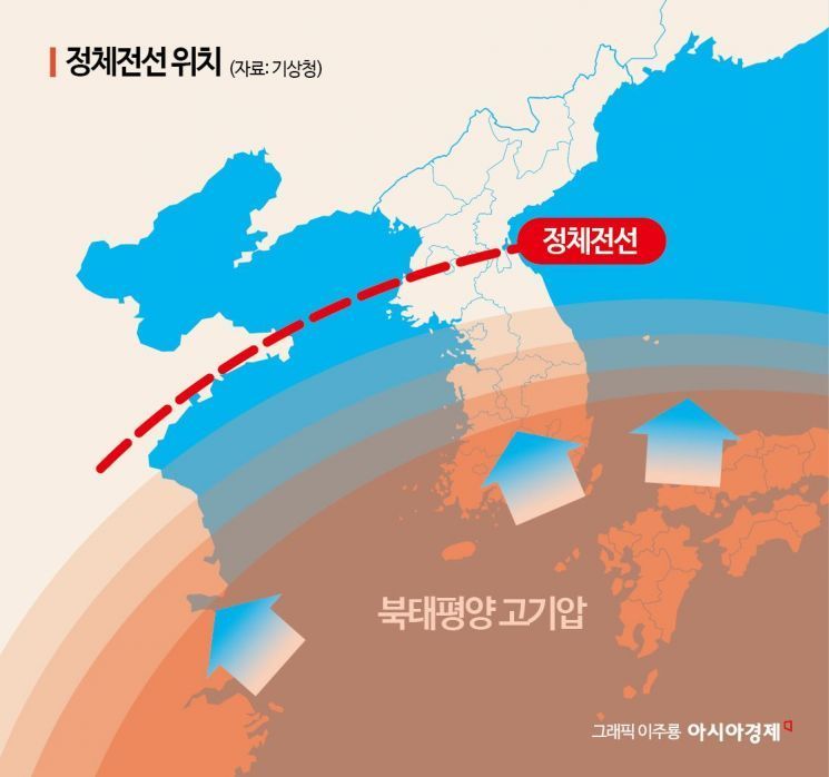
According to the Korea Meteorological Administration (KMA) on July 4, the monsoon ended in Jeju on June 26 and in the southern regions on July 1 as the stationary front moved away. In Jeju, this is the earliest end to the monsoon since 1973, when the nationwide meteorological observation network was established as the standard for weather records. The previous record was July 1, 1994. For the southern regions, the earliest end to the monsoon was June 30, 1973, making this the second earliest on record.
This was due to the unusually large northwestward expansion of the North Pacific high-pressure system, which pushed the stationary front northward into North Korea. As a result, Jeju and the southern regions came completely under the influence of the high-pressure system. The KMA stated, "Even if the stationary front moves south again, it is unlikely to affect Jeju or the southern regions, so we have analyzed that the monsoon has ended there." The agency added, "More detailed climate data will be available after further analysis, and after the summer, the monsoon period will be recalculated quantitatively based on all data, which may result in minor changes to the dates."
However, for the central regions, there is still uncertainty about the end of the monsoon, as the stationary front passing through North Korea may temporarily affect these areas. The timing of the monsoon's end is expected to change depending on atmospheric pressure variations, such as the southward movement of cold northern air, the expansion of the Tibetan high, and the development of tropical depressions. The KMA explained, "As cold northern air temporarily moves south, the stationary front may affect the central regions, bringing rain on July 4 and from the night of July 6 to July 7. However, as this is due to a weak stationary front within the North Pacific high-pressure system, precipitation amounts are not expected to be significant."
The heatwave and tropical nights are expected to continue for the time being. Currently, the North Pacific high is completely covering Korea, and hot, humid southwesterly winds are flowing in. The KMA stated, "The heatwave will persist this week, and most regions nationwide are expected to remain under heatwave advisories through next week, although there is considerable variability."
By region, the characteristics of the heatwave differ. In inland areas of the south, where the North Pacific high arrived early, strong sunlight and southwesterly winds are expected to make the perceived temperature even higher than the actual temperature. In the central and west coast regions, the combination of southwesterly winds, hot humid vapor, and strong sunlight will also push perceived temperatures above actual readings. On the east coast, the Foehn effect (where winds crossing mountains become hot and dry), along with southwesterly winds and sunlight, will keep nighttime temperatures high.
The KMA also noted that the formation of tropical disturbances (weather phenomena originating in the tropics) and typhoons will make atmospheric pressure patterns highly volatile, maintaining the possibility of localized heavy rain from showers or typhoons and intensifying heatwaves.
◆Sharp Increase in the Number of Heatwave and Tropical Night Days
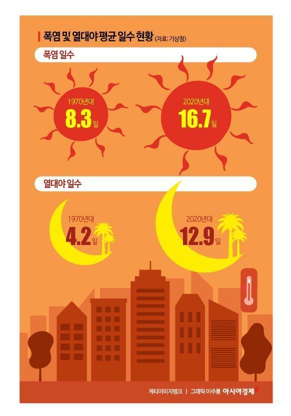
The number of days with heatwaves and tropical nights has been rising sharply each year. An analysis of annual heatwave and tropical night days from 1973 to 2024 shows that there was little change until the 2000s, but a significant increase began in the 2010s. Compared to the 1970s, the average number of heatwave days in the 2010s rose from 8.3 to 14.0 days, a 1.7-fold increase, while the average number of tropical night days increased from 4.2 to 9.0 days, a 2.1-fold increase. In the 2020s, these figures rose further to 16.7 and 12.9 days, respectively.
Based on the most recent 10 years (2015-2024), the average annual number of heatwave and tropical night days was 16.3 and 11.0, respectively, which is 5.3 and 4.4 days higher than the average for 1991-2020. Tropical nights mainly occurred in July and August, with the largest increase in August since the 2010s. The years 2024, 2018, and 1994, which had long and hot summers, ranked first to third in both heatwave and tropical night days.
The highest number of heatwave days was 31.0 in 2018, followed by 30.1 last year. In 2024, the number was 24.5, which is significantly higher than the previous second place of 16.8 in 1994. The trend for tropical night days is similar: 13.6 days in 2001-2010, 19.7 days in 2011-2020, and 28 days in 2021-2024.
Over the past 10 years, the highest average annual number of heatwave days was recorded in inland Gyeongsang Province, with Miryang at 33.6 days, Daegu at 33.4 days, and Uiseong at 32.6 days. For tropical night days, the highest numbers were observed in Jeju (Jeju 45.3 days, Seogwipo 37.6 days), Yeosu (30.0 days), Mokpo (28.2 days), Pohang (27.7 days), and Busan (27.2 days).
The increase in heatwave and tropical night days is largely attributed to climate change. According to the KMA's National Institute of Meteorological Sciences "2024 Global Atmospheric Watch Report," the background concentration of carbon dioxide in Korea last year reached record highs at all three observation sites: 430.7 ppm at Anmyeondo, 429.0 ppm at Gosan, and 428.0 ppm at Ulleungdo.
Anmyeondo, Gosan, and Ulleungdo are locations where the KMA has been monitoring climate change-related substances on the Korean Peninsula since 1997. The background concentration refers to measurements taken in well-mixed atmospheric conditions, minimizing local influences near the observation sites.
According to the U.S. National Oceanic and Atmospheric Administration, the global average background concentration of carbon dioxide in April 2024 was 422.8 ppm, an increase of 3.4 ppm from the previous year. This is the largest annual increase over the past 10 years.
The KMA emphasized, "For the time being, most regions nationwide are expected to experience a perceived temperature of around 33 degrees Celsius (with some areas exceeding 35 degrees), and the accumulation of heat due to the ongoing heatwave could lead to greater damage. Thorough precautions should be taken against heat-related illnesses."
© The Asia Business Daily(www.asiae.co.kr). All rights reserved.


