Integration and Visualization of Disaster and Hazard Data Across the Entire City
Mayor Jung: "We Will Protect Citizens' Lives Through Preemptive Disaster Prevention"
Hwaseong City in Gyeonggi Province will begin creating a 'Disaster Risk Map' that enables a comprehensive overview of major risk areas within the city.
On June 16, Hwaseong City announced that it recently held a 'Safety Measures Progress Review Meeting' presided over by Mayor Jung Myung-geun, where the city reviewed its response system for natural disasters such as heavy rain and heat waves and discussed plans for establishing a risk map. This meeting was held as a follow-up to the 'Safety and Security Inspection Meeting' presided over by the President on June 5.
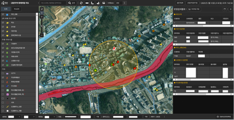 'Factory Area Fire Risk Map' developed by Hwaseong Corporation. The city plans to advance this system to create a 'Disaster Risk Map' to predict disasters in advance and respond proactively. Provided by Hwaseong City
The 'Disaster Risk Map' project aims to integrate and visualize disaster data across the entire city, systematizing the entire process of disaster prevention, response, and recovery. The core of the project is to predict disaster situations in advance and respond proactively through scientific analysis and spatial data.
Earlier, in January of this year, the city became the first local government to introduce a 'Fire Risk Map System,' which visualized risk information for more than 27,000 sites, including factories, logistics warehouses, and resource recycling facilities, as spatial data.
The city plans to advance the existing Fire Risk Map System into an 'Integrated Natural Disaster Risk Map' by comprehensively incorporating data related to natural disasters, such as steep slopes, areas at risk of collapse, flood-prone areas, and flood trace maps. The completed map will be used for customized maintenance projects in areas of repeated damage, preventive inspections, and the establishment of measures to prevent recurrence.
To this end, the city will establish a detailed implementation plan by the end of this month, including the scope of data collection, visualization system, and utilization strategies for the disaster risk map.
Mayor Jung stated, "Predicting disasters through statistics and data and preventing them in advance through swift administration is the most certain way to protect citizens' lives," adding, "We will refine the Disaster Risk Map to serve as a leading example that any local government nationwide can reference."
© The Asia Business Daily(www.asiae.co.kr). All rights reserved.
![Clutching a Stolen Dior Bag, Saying "I Hate Being Poor but Real"... The Grotesque Con of a "Human Knockoff" [Slate]](https://cwcontent.asiae.co.kr/asiaresize/183/2026021902243444107_1771435474.jpg)


