Starting tomorrow, monsoon rains are expected to fall on Jeju.
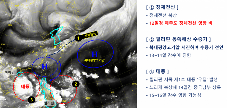
The Korea Meteorological Administration announced on June 11 that, due to the influence of a stationary front, rain is forecast to begin in Jeju from the early hours of June 12. Currently, the stationary front is located 200 to 300 kilometers south of Jeju.
The Korea Meteorological Administration expects the North Pacific high-pressure system to expand westward, pushing the stationary front northward. The average start date of the monsoon season in Jeju, based on data from 1991 to 2020, is June 19. If the forecast holds, this year's monsoon will begin about a week earlier than usual.
The earliest recorded start of the monsoon season in Jeju was June 10 in both 2020 and 2011, followed by June 12 in 1998. The average start dates for the monsoon in the southern and central regions are June 23 and June 25, respectively.
However, the official start date of the monsoon may be revised after further analysis. On June 13, the stationary front is expected to move eastward, but as the North Pacific high-pressure system continues to expand toward Korea, a large influx of hot and humid air currently located over the sea east of the Philippines will flow in along the edge of the high-pressure system.
Expected precipitation through June 13 is as follows: Jeju, 20 to 60 millimeters (with more than 80 millimeters possible in some areas); Gwangju, Jeonnam, Busan, and the southern coast of Gyeongnam, 10 to 40 millimeters; Ulsan and inland Gyeongnam, 5 to 30 millimeters; Jeonbuk, Daegu, and Gyeongbuk, 5 to 20 millimeters; and Chungcheong, 5 to 10 millimeters. Starting June 14, rain is expected in most regions nationwide, including the Seoul metropolitan area and Gangwon.
There is also a possibility of heavy rainfall on June 15 and 16. As a large mass of cold air moves south from the north and collides with the hot and humid air over Korea, atmospheric instability may lead to heavy downpours.
Typhoon Ewiniar, the first typhoon of the year in the northwest Pacific, which formed 580 kilometers east of Da Nang in the Philippines, may affect precipitation on June 15 and 16. Ewiniar is expected to make landfall in southern China and move northeast, maintaining its strength as a typhoon until the morning of June 15, after which it is forecast to weaken into a tropical depression and dissipate.
© The Asia Business Daily(www.asiae.co.kr). All rights reserved.


