Polling Station Locations and Real-Time Population Density
at a Glance with the Smart Map
Yongsan-gu in Seoul will provide a polling station congestion information service through its "real-time Smart Map" for the 21st presidential election (main voting on June 3, early voting on May 29-30).
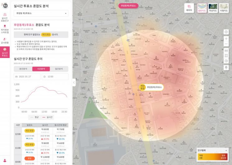 Yongsan real-time Smart Map real-time polling station congestion service screen. Provided by Yongsan-gu.
The real-time Smart Map, launched by Yongsan-gu last month, uses mobile base station data to determine population density every five minutes and offers residents map-based daily life information. During the election period, it will visually display the locations of all polling stations in the district and real-time population congestion within a 150-meter radius. When a polling station is selected, users can check basic information along with the current congestion status, categorized into four levels: low, normal, slightly crowded, and crowded.
The district explained, "This service was introduced to help voters easily and quickly find nearby polling stations and check congestion in advance, enabling smooth voting," adding that it is "an administrative service closely tied to daily life, utilizing map-based technology."
The Yongsan real-time Smart Map can be accessed from the "Frequently Used Services" menu on the main page of the district office's website. The district also plans to expand its content in the future to include a variety of public information such as tourism, transportation, and safety.
Park Heeyoung, Mayor of Yongsan-gu, stated, "As a result of continuously developing new content that can be implemented through the map service on the newly launched Yongsan real-time Smart Map last month, we planned the polling station congestion feature," and added, "We will continue to expand the service to provide integrated public information in various fields such as tourism, transportation, and safety."
© The Asia Business Daily(www.asiae.co.kr). All rights reserved.
![Clutching a Stolen Dior Bag, Saying "I Hate Being Poor but Real"... The Grotesque Con of a "Human Knockoff" [Slate]](https://cwcontent.asiae.co.kr/asiaresize/183/2026021902243444107_1771435474.jpg)


