The technology verification of the Synthetic Aperture Radar (SAR) system, developed domestically and launched into space, has been successfully completed.
According to KAIST on May 25, the SAR was mounted on the next-generation small satellite No. 2, which was launched on May 25, 2023, aboard the third Nuri rocket. The core missions of the next-generation small satellite No. 2 included the technology verification of the domestically developed SAR and all-weather Earth observation, which it has carried out over the past two years.
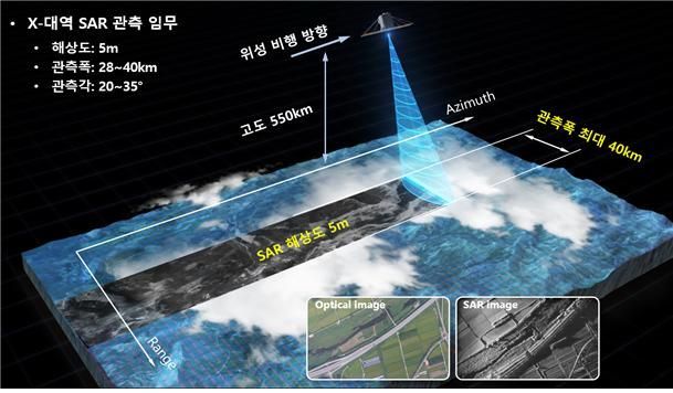 Conceptual diagram of Earth observation using the next-generation small satellite No. 2 synthetic aperture radar. Provided by KAIST
The SAR system, designed, manufactured, ground-tested, and evaluated by the KAIST Satellite Technology Research Center for the first time in Korea, has been successfully localized and completed its technology verification in orbit.
After the satellite's launch, the next-generation small satellite No. 2 conducted an average of 3 to 4 imaging sessions per day, during which its functions were checked and its technology verified. In this process, it completed more than 1,200 Earth observation missions. According to KAIST, even now, after the satellite's mission lifetime has passed, the SAR continues to perform well, and observation missions are still being carried out stably.
The SAR developed by the KAIST Satellite Technology Research Center is an active sensor that uses electromagnetic waves, enabling all-weather imaging regardless of day or night or weather conditions. Its ability to observe even during dark nights or in cloudy or rainy weather is particularly useful for continuously monitoring regions like the Korean Peninsula, where rain and clouds are frequent.
In particular, the fact that the SAR system was mounted on a 100 kg-class small satellite (next-generation small satellite No. 2) and successfully completed its observation mission is significant in terms of securing miniaturization and lightweight technology for spaceborne SAR systems and enhancing the competitiveness of domestic satellite technology.
Since March last year, the KAIST Satellite Technology Research Center has been collaborating with the Korea Polar Research Institute and the Korea National Park Research Institute to prioritize imaging of areas of interest for Arctic cryosphere change analysis and forest area change detection using the SAR system. After repeatedly observing areas of interest in the Arctic sea ice, the Remote Sensing Cryosphere Information Center at the Korea Polar Research Institute has been precisely tracking changes in sea ice area and structure due to climate change through time-series analysis of the observation results.
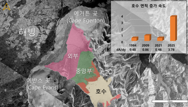
Recently, the Korea Polar Research Institute combined observation data from the next-generation small satellite No. 2 and the European Space Agency's Sentinel-1 to detect that the area of the lake behind the Milne Ice Shelf in Canada increased by 15 km² between 2021 and 2025. This is considered an important signal indicating the accelerating pace of climate change in the Arctic.
Kim Hyuncheol, head of the Remote Sensing Cryosphere Information Center at the Korea Polar Research Institute, stated, "These research results provide important evidence of how vulnerable Arctic ice shelves are to climate change," and added, "We will continue to conduct ongoing observation and analysis using the SAR on the next-generation small satellite No. 2 to predict environmental changes in the Arctic and strengthen international cooperation."
The KAIST Satellite Technology Research Center, in collaboration with the Climate Change Research Center of the Korea National Park Research Institute, has also made it possible for SAR imagery from the next-generation small satellite No. 2 to be used in research for detecting phenological changes due to climate change, monitoring changes in forest ecosystems such as conifer dieback in high-altitude areas and landslides.
In addition, research is being conducted to analyze the spatial distribution of carbon storage in forest areas using satellite imagery and to improve analytical accuracy by comparing these results with field measurements.
The SAR is not only unaffected by light and weather, but can also observe through flames and smoke in the event of a wildfire. This makes it an effective tool for regularly monitoring large protected areas and is expected to contribute to the development of future forest protection policies.
Lee Kwanghyung, president of KAIST, said, "The next-generation small satellite No. 2 is the result of KAIST's advanced space technology and the innovative capabilities of our researchers," and added, "The achievements of the past two years signal the great potential KAIST holds for nurturing space technology talent and advancing research and development in the future."
© The Asia Business Daily(www.asiae.co.kr). All rights reserved.


