Establishment of District Unit Plans for Development Restriction Zone Release
Urban Management Plans Considering Characteristics of Each Village
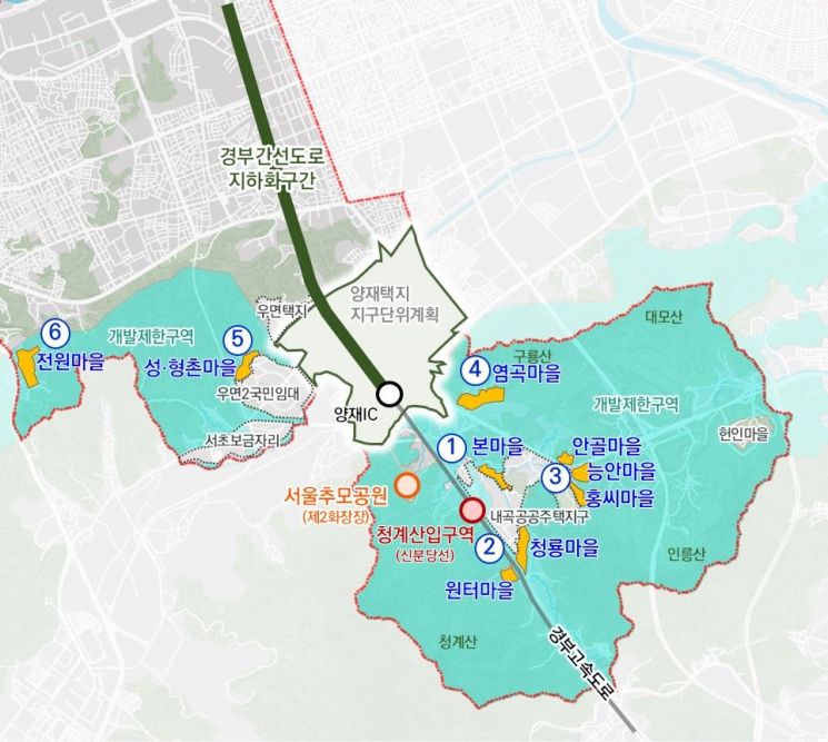
The land use zones of 10 villages near Cheonggyesan Entrance Station on the Shinbundang Line, which were previously designated as development-restricted areas, have been upgraded, allowing this area to be developed as a specialized low-rise residential district.
Seocho-gu, Seoul (District Mayor Jeon Seong-su) announced on the 26th that the "District Unit Plan and Topographic Map for the Development-Restricted Area Release Zone in Seocho-gu" have been officially decided and announced. The target area consists of 10 villages and 6 zones, a result achieved by Seocho-gu in collaboration with Seoul Mayor Oh Se-hoon after 16 years.
The main contents of the district unit plan include upgrading the land use zone from Type 1 Exclusive Use (building coverage ratio 50%, floor area ratio 100% or less) to Type 1 General Use (building coverage ratio 50%, floor area ratio 150% or less, up to 3 floors) considering local conditions, architectural use planning reflecting village characteristics, securing roads for improved pedestrian environment and vehicle traffic convenience, and architectural design guidelines to preserve the calm characteristics of detached housing areas upon new construction.
The 10 villages subject to this land use zone upgrade are Bonmaeul, Cheongnyongmaeul, Wonteomaeul, Hongssi Maeul, Neung-anmaeul, Angolmaeul, Yeomgokmaeul, Seongchonmaeul, Hyeongchonmaeul, and Jeonwonmaeul in Seocho-gu. These areas are medium to large-scale collective settlements formed through the residential structure improvement project in the 1970s and were released from development-restricted zones by the Ministry of Land, Infrastructure and Transport in 2002 and 2006.
According to the Development-Restricted Area Act, areas released from development-restricted zones are required to establish urban management plans (district unit plans) mandatorily, considering urban management aspects.
The district office initiated the establishment of the district unit plan by commissioning a study in 2008. Including plans for upgrading land use zones, after five reviews and seven consultations from 2010 to 2016, the plan was "amended and approved" by the Seoul City Urban and Architectural Joint Committee last June.
The purpose of this district unit plan is not merely to upgrade land use zones but to lay the groundwork for realizing a sustainable Seoul-style low-rise residential area by forming differentiated village values for collective settlement detached housing areas, explained a district official.
Considering the characteristics of each village, the plan establishes building density and use plans so that newly constructed buildings after the district unit plan harmonize with existing buildings and maintain a calm low-rise residential environment. Architectural design guidelines to protect the characteristics of detached housing areas are also provided. Additionally, building setback lines have been designated to ensure pedestrian safety and smooth vehicle traffic within the villages, and separate parking lot creation standards within the villages have been established.
District Mayor Jeon Seong-su stated, "The establishment of this district unit plan is the result of the combined efforts and cooperation of the Seoul city government and district council members over the past 16 years to resolve a long-standing issue. We will continue to strive to make this a more livable low-rise residential area for residents."
© The Asia Business Daily(www.asiae.co.kr). All rights reserved.
![Clutching a Stolen Dior Bag, Saying "I Hate Being Poor but Real"... The Grotesque Con of a "Human Knockoff" [Slate]](https://cwcontent.asiae.co.kr/asiaresize/183/2026021902243444107_1771435474.jpg)


