The platform industry has stepped up efforts to provide information on dangerous situations through map services to ensure user safety.
On the 17th, according to related industries, Naver conducted a new update of Naver Maps focusing on delivering detailed information about accidents occurring within residential areas and strengthening disaster information guidance during navigation use.
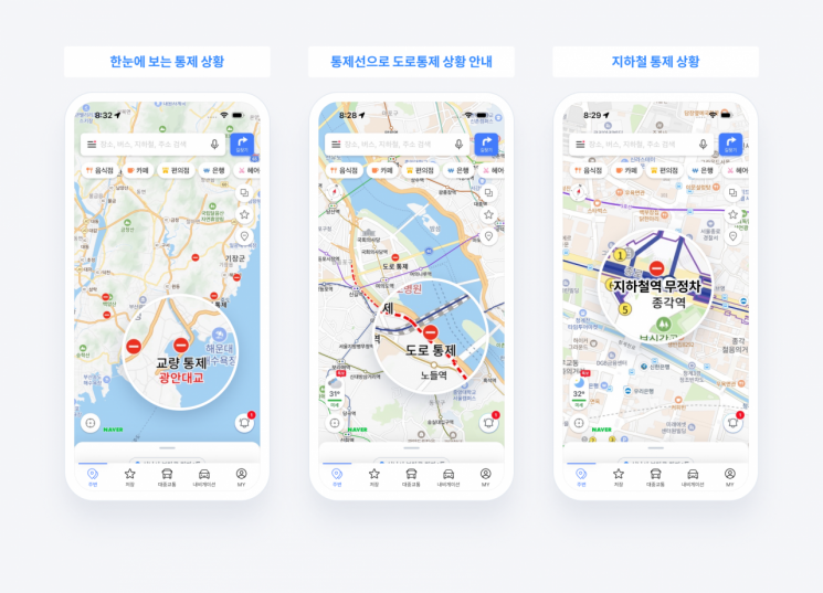
First, when various accidents such as road closures, construction, traffic accidents, and disasters occur on roads, information is provided based on the administrative district of the user's registered home or company information or current location. In addition, various information is collected through administrative agencies, real-time news, and user reports, and summarized in card form so that users can check it in a timely manner. These cards include information on the control status of major roads and bridges affected by accidents or disasters, as well as suspension or delay information for subway and train boarding stations.
Users can check the details of incidents and the affected area information through the information cards, and it is also possible to directly observe the scene via representative closed-circuit television (CCTV) linked to the incident location on the card. The detailed page provides specific incident descriptions, occurrence and end times, and more. In the case of disaster incidents, a link is provided to Naver Encyclopedia's disaster action guidelines to assist users in responding appropriately.
Furthermore, Naver Maps reorganized the existing four types of icons (traffic control, accidents, construction, others) into seven types by adding disaster alerts such as flood warnings, dam discharge forecasts, and large fires. The redesigned icons are highlighted on the map to enhance visibility and allow users to recognize them more intuitively.
Information on road and subway station controls, which previously required activation of the traffic information button on Naver Maps, is now provided by default. Control sections including bridges, tunnels, and underpasses are marked with red dotted lines on the map.
Additionally, during navigation route searches, areas with flood warnings and dam discharge notices are pre-marked on the route guidance line to alert users. Unexpected situations during driving are also communicated to users in real time. Risk information along the route is displayed at the top of the mobile navigation screen, and voice guidance is provided when approaching or near incident locations or nearby accidents.
Choi Seung-rak, the leader in charge of Naver Maps services, stated, "We plan to continuously advance Naver Maps as an ‘all-in-one platform’ that provides convenient and precise mobility experiences and supports the entire user journey."
Kakao provides real-time information related to dangerous situations such as floods, inundations, and road controls on major services including the portal Daum, KakaoTalk Open Chat, and KakaoMap to help users prevent damage caused by heavy rain.
Daum operates a special page where users can comprehensively check weather-related information. Users can view special weather reports issued by the Korea Meteorological Administration, weather maps, forecasts, weather alerts, the latest news, and regional disaster text messages.
A feature is also provided for users to share real-time regional damage situations such as floods and inundations. On KakaoTalk Open Chat, a ‘Heavy Rain Tab’ is opened where users can share weather conditions through the ‘Real-time Nationwide Weather Situation’ Open Chat Lite.
KakaoMap plans to guide detour routes to prevent users from entering roads that are completely closed due to heavy rain damage such as inundations and landslides. Using the CCTV function, users can also check real-time conditions on major roads nationwide.
T Map Mobility currently offers a flood risk area alert service on T Map. When a user enters within a 1.5 km radius of a flood warning point while driving, the navigation screen and voice guidance notify the user of the dangerous situation. Information on heat shelters, earthquake evacuation sites, civil defense shelters, hazardous material evacuation locations, and road freezing risk sections is also provided. T Map Mobility plans to launch a dam discharge alert service for T Map maps next month.
© The Asia Business Daily(www.asiae.co.kr). All rights reserved.
![Clutching a Stolen Dior Bag, Saying "I Hate Being Poor but Real"... The Grotesque Con of a "Human Knockoff" [Slate]](https://cwcontent.asiae.co.kr/asiaresize/183/2026021902243444107_1771435474.jpg)


