Kakao announced on the 3rd that it will newly provide the 'Barrier-Free Sharing Trail' map on its mobile map application, KakaoMap.
This initiative is part of a business agreement signed last March with the Korea Forest Welfare Institute under the Korea Forest Service to provide digital information on barrier-free sharing trails. The Barrier-Free Sharing Trail is a forest path created by the Korea Forest Welfare Institute with deck roads and loess-paved paths in the forest, allowing walking-vulnerable groups such as people with disabilities, pregnant women, and the elderly to safely enjoy the forest. This is the first time that information on barrier-free sharing trails nationwide has been added to a map app.
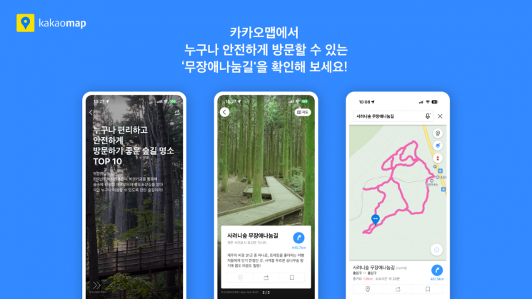
Based on the nationwide barrier-free sharing trail information established by the Korea Forest Welfare Institute, KakaoMap has newly added 113 barrier-free sharing trails across the country. By searching for barrier-free sharing trails on KakaoMap, users can easily find information such as the location, route, total distance, and entrances of 113 barrier-free sharing trails nationwide.
Additionally, KakaoMap released a themed map the day before titled "Top 10 Forest Trail Attractions Convenient and Safe for Everyone to Visit." This themed map introduces 10 locations with excellent natural environments and unique attractions, including ▲ Namimyeon Barrier-Free Sharing Trail (Geumsan-gun, Chungnam), where you can experience primeval forests ▲ Saryeoni Forest Barrier-Free Sharing Trail (Jeju City, Jeju), a trekking hotspot ▲ Mansusan Barrier-Free Sharing Trail (Incheon City), which connects to the mountain summit, among others.
© The Asia Business Daily(www.asiae.co.kr). All rights reserved.
![Clutching a Stolen Dior Bag, Saying "I Hate Being Poor but Real"... The Grotesque Con of a "Human Knockoff" [Slate]](https://cwcontent.asiae.co.kr/asiaresize/183/2026021902243444107_1771435474.jpg)


