The latest orthophotos from the national land satellite covering the entire Korean Peninsula will be available for immediate viewing on the web.
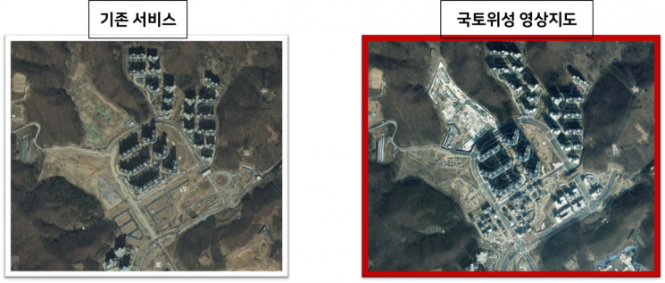 An example of the National Land Satellite Map (right) that allows you to check the progress of apartment complex construction. / Photo by Ministry of Land, Infrastructure and Transport
On the 12th, the National Geographic Information Institute of the Ministry of Land, Infrastructure and Transport announced that it will launch a web service for the National Land Satellite-based video map (National Land Satellite Map) starting from the 14th.
Through this service, the National Geographic Information Institute explained that it will be possible to quickly provide the latest satellite maps using regularly captured national land satellite images. Unlike the existing national land information platform based on aerial photographs updated precisely on an annual basis and the video map services of private search portals, this service allows users to check the current appearance in real time. It also resolves the inconvenience of using national land satellite orthophotos, which take a long time to download due to their higher positional accuracy and resolution compared to images taken from satellites.
In addition, the National Geographic Information Institute stated that it has significantly revamped the existing national land information platform service to allow comprehensive use of national land satellite information-related services in one place.
Specifically, to enhance the usability of national land satellite information, platform functions such as conditional search, image comparison, and manual provision have been improved, and search conditions such as administrative district unit search and designation of areas of interest have been added to easily query national land satellite image product information. Eight new contents, including national land satellite image comparison, national land satellite shooting plans and announcement status, and the latest images of our neighborhood, have also been released. In particular, the latest images of our neighborhood content allows users to view national land satellite images and aerial images of designated areas of interest.
Jo Wooseok, Director of the National Geographic Information Institute, said, "This will be an opportunity for the public to access satellite images more easily and increase familiarity," adding, "We will continue to expand services that the public can feel, such as the National Land Satellite Map."
© The Asia Business Daily(www.asiae.co.kr). All rights reserved.
![Clutching a Stolen Dior Bag, Saying "I Hate Being Poor but Real"... The Grotesque Con of a "Human Knockoff" [Slate]](https://cwcontent.asiae.co.kr/asiaresize/183/2026021902243444107_1771435474.jpg)


