On the 29th, Gwangju Bukbu Fire Station announced that it will create a 'Wildfire Suppression Operation Map' for three major mountains in the district to respond to the frequent wildfires during the dry season and take proactive measures.
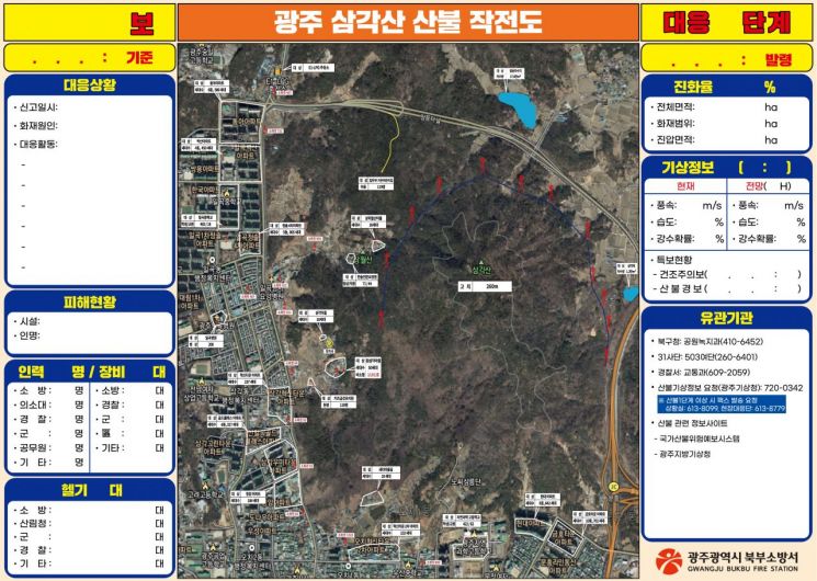
According to Bukbu Fire Station on the 29th, they surveyed Mudeungsan, Samgaksan, and Unamsan located in Buk-gu to create a map indicating fire truck access routes, major firefighting targets such as villages adjacent to forests, and natural water sources for firefighting, enabling efficient response in case of fire. The map has been placed on-site.
The wildfire suppression operation map visualizes the overall terrain of the mountains and is used not only during actual fires but also as a training material for firefighters during regular drills. This enhances on-site adaptability during wildfire incidents, strengthens wildfire response capabilities, and is expected to improve efficiency in conducting firefighting operations with related agencies.
A fire official stated, "The success of operations depends on initial response to fires. We will continuously revise and supplement the operation maps and strive to minimize wildfire damage through repetitive training."
© The Asia Business Daily(www.asiae.co.kr). All rights reserved.
![Clutching a Stolen Dior Bag, Saying "I Hate Being Poor but Real"... The Grotesque Con of a "Human Knockoff" [Slate]](https://cwcontent.asiae.co.kr/asiaresize/183/2026021902243444107_1771435474.jpg)


