Hyundai AutoEver announced on the 2nd that it has developed indoor parking lot map construction technology. As parking lot guidance services in vehicle navigation systems expand, this technology aims to efficiently create and update indoor parking lot maps necessary for operating such services.
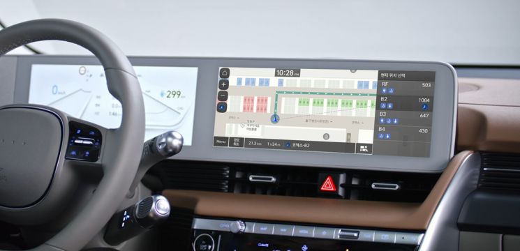 Indoor navigation service using indoor parking lot maps built by Hyundai AutoEver. Photo by Hyundai Motor Group
Indoor parking lot maps are used to guide drivers on routes and locations within facilities that have large parking areas, such as apartments or large shopping malls. They contain information to provide various convenience features, including the number of available parking spaces, elevator locations, and entrance information.
To efficiently build indoor parking lot maps, Hyundai AutoEver created an ‘Indoor Survey System’ and also developed an ‘Indoor Survey Solution’ that processes the information obtained through this system into maps.
The Indoor Survey System is implemented as hardware that can be attached to and detached from vehicles. It collects location and surrounding information inside indoor parking lots through various sensors, including ▲54-channel cameras ▲LiDAR (Light Detection and Ranging) ▲GNSS (Global Navigation Satellite System) ▲IMU (Inertial Measurement Unit) ▲DMI (Distance Measuring Instrument).
The Indoor Survey Solution is software designed to create maps based on the diverse data secured by the Indoor Survey System. This solution includes ▲real-time sensor data collection tools ▲indoor mapping equipment location estimation software ▲IMU position error correction software ▲3D data generation and post-processing software.
The process of constructing indoor parking lot maps is as follows. First, a vehicle equipped with the Indoor Survey System drives through the indoor parking lot along a predetermined survey route while collecting data based on the ROS (Robot Operating System). The data is processed using the SLAM (Simultaneous Localization and Mapping) method. SLAM refers to simultaneously estimating location and creating maps by generating a map of the surrounding environment through sensors while moving and tracking sensor positions on the map to continue map creation.
The data collected by the Indoor Survey System is processed through the Indoor Survey Solution, which models the space based on 3D data. Various information such as parking lot floor and wall markings and signs identified during the survey is added to the modeled space to complete the map.
The completed map has an accuracy within an error range of 1 meter. Because it is created through direct on-site surveys, it is more accurate than map-based drawings. Additionally, it offers advantages such as lower costs compared to outsourced field surveys and faster responses to changes.
The internalized technology developed this time can be applied not only to indoor parking lots but also to indoor maps in general. Indoor maps can be used for safety control and monitoring in smart factories and office buildings, and are expected to be utilized for managing the movement paths of robots operating indoors.
© The Asia Business Daily(www.asiae.co.kr). All rights reserved.
![Clutching a Stolen Dior Bag, Saying "I Hate Being Poor but Real"... The Grotesque Con of a "Human Knockoff" [Slate]](https://cwcontent.asiae.co.kr/asiaresize/183/2026021902243444107_1771435474.jpg)


