The Ministry of Environment will strengthen flood prevention infrastructure by preparing customized measures for 34 major cities by 2026. The number of forecast points will be increased to 223 by 2025 to enable flood forecasting not only for main rivers but also for tributaries and streams, and the lead time for forecasts using artificial intelligence (AI) will be doubled from the current 3 hours to 6 hours.
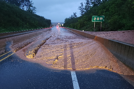
On the 10th, the Ministry of Environment announced flood damage prevention measures in line with the 'Summer Natural Disaster Countermeasure Period,' which runs from the 15th of this month to October 15th. Anticipating more frequent and larger floods due to recent climate change, the Ministry plans to strengthen flood forecasting and expand new infrastructure in addition to maintaining existing facilities.
First, the Ministry plans to establish and expand customized flood prevention infrastructure plans (specific river basin flood control plans) for 34 major cities by 2026. For areas deemed urgently in need of flood countermeasures, such as Pohang, Gyeongju in Gyeongbuk, and Busan, customized flood countermeasures will be established by July. Starting this month, AI and digital twin (virtual model)-based urban flood forecasting will be piloted in the Dorimcheon basin and expanded to Pohang City in Gyeongbuk, Changwon City in Gyeongnam, Gwangju, and others by next year. Additionally, the number of flood forecast points will be increased from the current 75 to 223 by 2025 to cover not only main rivers but also tributaries and streams. Using AI, the forecast lead time will be advanced to '6 hours before,' doubling the current lead time.
Flood information delivery will also become more intuitive. Instead of terms like "△△ Bridge exceeding alert water level," the information will be clearly understandable, such as "Water level reached for flood preparedness at the riverside parking lot near △△ Bridge." The number of nationwide flood information provision points has increased to 574, up by 165 from 409 in 2020. A flood risk map including 500-year frequency floods and past maximum flood volumes will be completed by 2024, and already completed maps such as national rivers (67), local rivers (3,511) flood inundation maps, and 591 town and township urban flood maps will be made available online.
To secure response capabilities for urban flooding and river overflows, the safety of existing infrastructure will be reinforced. River embankments in flood-vulnerable areas nationwide will be maintained, and sewer pipelines will be intensively upgraded. To support this, the sewer improvement budget, which was around 100 billion KRW annually, was increased to 154.1 billion KRW in 2023, and the national river maintenance budget, previously about 350 billion KRW annually, was raised to 451 billion KRW.
Furthermore, to prevent accidents caused by manhole covers being lost due to flooding, the sewer design standards were revised in December last year to mandate the installation of safety devices on new manholes in frequently flooded areas. Starting with Seoul, where manhole accidents occurred last year, the installation of manhole fall prevention facilities is being gradually expanded. From February to March this year, the Watershed (Local) Environmental Offices conducted a survey of flood risk factors along all sections of national rivers, designating 390 flood-vulnerable districts based on the results.
For these flood-vulnerable districts, countermeasures such as resident evacuation plans and emergency recovery plans have been established reflecting the characteristics of each district. To enable nearby residents to recognize and prepare for flood risks in advance, a resident-agency consultative body will be formed to share the survey results and countermeasure status and provide flood information. During the natural disaster countermeasure period, if a crisis such as heavy rain is expected, the crisis response meetings, which were previously mainly operated by the Korea Meteorological Administration and flood control offices, will be expanded to include water management agencies such as the Korea Water Resources Corporation and Korea Hydro & Nuclear Power. Specialized meteorological information and dam operation status will be shared to support decision-making for dam discharge and flood forecasting.
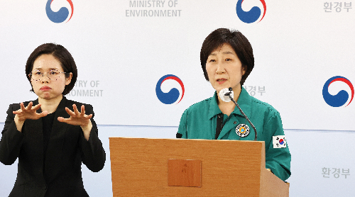
To prepare for rising river water levels due to heavy rain and dam discharge, a system will be established to jointly utilize about 8,000 closed-circuit television (CCTV) cameras used by agencies such as the Watershed (Local) Environmental Offices, flood control offices, and Korea Water Resources Corporation. Through this, comprehensive real-time monitoring of water levels and embankments along all 73 national rivers (3,601 km) will be possible. Han Hwa-jin, Minister of Environment, stated, "We will proactively manage factors vulnerable to urban flooding and river floods in preparation for extreme rainfall," and added, "We will collaborate seamlessly with related agencies to minimize casualties and property damage caused by floods."
© The Asia Business Daily(www.asiae.co.kr). All rights reserved.
![Clutching a Stolen Dior Bag, Saying "I Hate Being Poor but Real"... The Grotesque Con of a "Human Knockoff" [Slate]](https://cwcontent.asiae.co.kr/asiaresize/183/2026021902243444107_1771435474.jpg)


