Passing low pressure brings heavy rain nationwide
Rainfall concentrated from afternoon of 28th to early morning of 29th
Nationwide cold wave warning possible from 30th
Seoul morning lows: -6°C on 30th, -8°C on 1st
First snow possible on West Coast and Jeju from 30th to 2nd
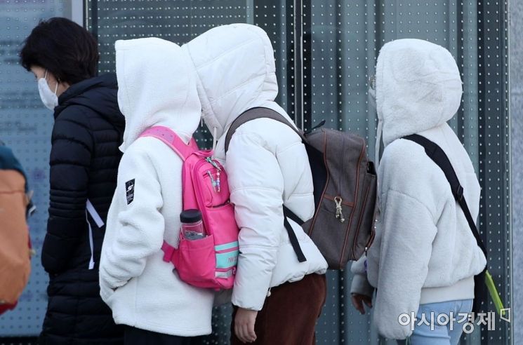 On the 27th, when the morning low temperature dropped below freezing mainly in the central region, citizens dressed in thick clothes hurried their steps around Gwanghwamun Square in Seoul. Photo by Kim Hyun-min kimhyun81@
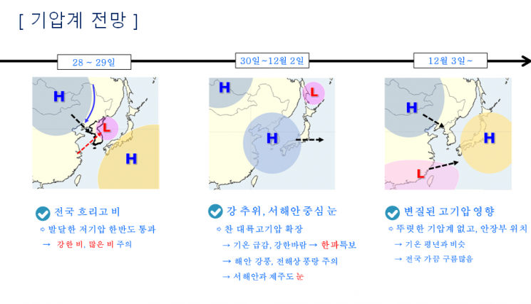
[Asia Economy Reporter Han Jinju] Heavy rain will fall nationwide on the 28th and 29th, followed by a cold wave starting on the 30th, causing morning low temperatures to drop below freezing. After the rain stops, temperatures will drop significantly, and strong winds will blow, making it the coldest autumn so far.
On the 27th, the Korea Meteorological Administration held a briefing and forecasted that a developing low-pressure system passing over the Korean Peninsula from Monday the 28th will bring heavy and widespread rain nationwide. The rain will mainly affect the central regions, with daily precipitation expected to exceed the late November extreme value (60.3mm).
Rain will begin in the western regions on the morning of the 28th, intensify from the afternoon until the early hours of the 29th, and continue until the morning. During the peak rainfall period, heavy rain accompanied by thunder and lightning will fall at a rate of about 20 to 30mm per hour.
From the 28th to the 29th, mountainous areas of Jeju Island, influenced by terrain, will receive over 120mm of rain. The Seoul metropolitan area, Gangwon Yeongseo, Chungcheong region, eastern Jeonnam and southern coastal areas, Gyeongnam coastal areas, Jeju, areas near Jirisan, and the five islands in the West Sea will see 20 to 80mm of rain. Gangwon Yeongdong, other southern regions, and Ulleungdo and Dokdo will receive 10 to 50mm of rain. Given the expected heavy rainfall, preemptive maintenance is necessary to prevent fallen leaves and debris from blocking drainage systems.
Park Jeongmin, a forecaster and analyst at the Korea Meteorological Administration, explained, "After the rain stops, from the afternoon of the 29th, cold winds will begin, marking the start of severe cold. Temperatures will plummet, and there is a possibility of cold wave warnings being issued nationwide. From the 1st, temperatures in the central and northern regions will drop below minus 10 degrees Celsius, and the wind chill on the 30th and 1st will approach minus 20 degrees Celsius, resulting in extremely cold weather."
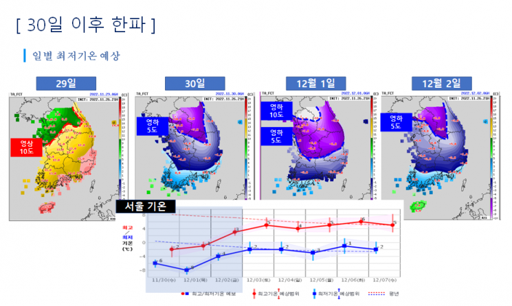
A cold wave will arrive starting on the 30th, with morning low temperatures falling below freezing in most areas. The minimum temperature on the 29th will be around 10 degrees Celsius, dropping to around minus 5 degrees Celsius on the 30th, a decrease of more than 15 degrees, prompting the issuance of cold wave warnings nationwide. Most areas, except some parts of the west and south coasts, are expected to have cold wave alerts. The morning low temperature in Seoul will be -6 degrees Celsius on the 30th and drop to -8 degrees Celsius on the 1st.
Cold wave warnings are issued between October and April when the morning low temperature drops by 15 degrees or more compared to the previous day, falls below 3 degrees Celsius, and is expected to be 3 degrees lower than the average. Cold wave advisories are issued when the temperature drops by 10 degrees or more compared to the previous day. Warm autumn weather will continue through November before transitioning to winter weather, making the perceived cold even more intense.
Between the 30th and the 1st, the first snow is expected on the Jeolla west coast and Jeju Island. The Seoul metropolitan area is expected to experience generally clear weather. Due to strong winds, gale warnings may be issued for all seas from the 30th to the 1st, with storm warnings likely in offshore waters. Strong wind advisories may be issued for all coastal and island areas, especially in the mountainous regions of Gangwon.
Forecaster Park said, "Usually, a cold wave warning is issued after a cold wave advisory is announced and the cold persists, but this time, most areas will have cold wave warnings issued immediately. Because the cold air will arrive before the rain that falls on the 28th and 29th soaks into or dries on the ground, icy roads are likely to form, so caution is needed for traffic safety."
© The Asia Business Daily(www.asiae.co.kr). All rights reserved.
![Clutching a Stolen Dior Bag, Saying "I Hate Being Poor but Real"... The Grotesque Con of a "Human Knockoff" [Slate]](https://cwcontent.asiae.co.kr/asiaresize/183/2026021902243444107_1771435474.jpg)


