The Ministry of Land, Infrastructure and Transport announced on the 23rd that it dispatched a Korean delegation to the 8th ESDI Conference held in Dushanbe, Tajikistan from September 21 to 22 to strengthen international cooperation in the field of spatial information and expand infrastructure among member countries of the Eurasian Spatial Data Infrastructure (ESDI) consortium.
ESDI is a consortium consisting of six Eurasian countries including Korea, Tajikistan, Kyrgyzstan, Kazakhstan, Uzbekistan, Belarus, and Mongolia, aimed at building and expanding the Eurasian spatial data infrastructure.
The Korean delegation was organized around the National Geographic Information Institute, the main agency responsible for spatial information, along with the Spatial Information Industry Promotion Agency (a new member of the consortium) and the Korea Land and Geospatial Informatix Corporation.
During the conference, the Korean delegation introduced the latest technologies related to geodesy, map production, and land management in Korea, discussed cooperation plans in the spatial information field with ESDI member countries, and deliberated on the construction of National Spatial Infrastructure Portals and the development and utilization of land information by country.
On the first day of the conference, September 21, the National Geographic Information Institute delivered a keynote speech titled "Trends in Korea's Spatial Information and Cooperation Plans with Eurasian Countries," while the Korea Land and Geospatial Informatix Corporation presented on "Technological Innovation in Korea's Land Management Sector," covering modernization of land administration and related technologies of the National Spatial Data Infrastructure (NSDI).
Additionally, the Korean delegation introduced cooperation plans with Eurasian countries and Korea's latest technologies in geodesy, map production, and land management, and provided consultation on customized spatial information infrastructure construction and operation for each ESDI member country.
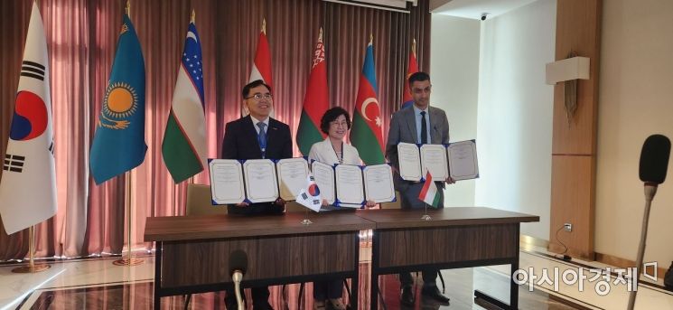
On the second day, September 22 (19:00 Korean time, 15:00 local time), the National Geographic Information Institute signed a memorandum of understanding with newly participating ESDI institutions to expand the Eurasian spatial data infrastructure.
Through this agreement, the new participating institutions agreed to actively cooperate with Korea in various fields including ① development of the ESDI geospatial information system, ② capacity building and information exchange in GIS, surveying, map production, photogrammetry, and remote sensing, ③ sharing experiences in geospatial information policy formulation, and ④ exchange of experts in the GIS field.
Furthermore, the Korean delegation held bilateral meetings with Tajikistan's key spatial information agencies, the Land Management Committee and the Aerogeodesy agency.
In the bilateral meetings, the Korean side provided consulting for expanding Tajikistan's spatial information infrastructure and expressed a commitment to mutual cooperation for discovering spatial information projects and training experts in Tajikistan.
Kim Hye-won, Director of Planning and Policy at the National Geographic Information Institute, said, "This conference was an opportunity to pave the way for domestic spatial information companies to enter the Eurasian market, which had been closed due to COVID-19," and added, "We will continue to strive to introduce, share, and spread Korea's advanced technologies and systems."
© The Asia Business Daily(www.asiae.co.kr). All rights reserved.
![Clutching a Stolen Dior Bag, Saying "I Hate Being Poor but Real"... The Grotesque Con of a "Human Knockoff" [Slate]](https://cwcontent.asiae.co.kr/asiaresize/183/2026021902243444107_1771435474.jpg)


