On the Night of the 17th, the Intensity of the Typhoon Strengthened to 'Super Strong'
Central Pressure Near Jeju Comparable to Typhoon Hinnamnor at Closest Approach
On the 18th, Direction Shifts Eastward and Intensity Slightly Weakens
On the 19th, 30~60mm of Rain per Hour Expected on Jeju and Gyeongsang Coastal Areas
Over 150mm of Heavy Rain Expected on Gyeongsang Coastal Areas Until the 19th
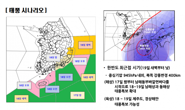
[Asia Economy Reporter Han Jinju] Typhoon Nanmadol, the 14th typhoon of the season, will develop into a 'super typhoon' scale on the night of the 17th. It is the second typhoon to develop into a 'super typhoon' strength following Hinnamnor. The time when it will be closest to Jeju Island is between dawn and morning on the 19th, bringing strong winds and heavy rain mainly to the coastal areas of Gyeongsang Province and Jeju.
The Korea Meteorological Administration (KMA) stated in a briefing on the 17th that the central pressure of Typhoon Nanmadol will reach around 945 hPa and the radius of strong winds will be about 400 km during the early morning to morning hours of the 19th, when the typhoon is closest to the Korean Peninsula. Both the intensity and scale are comparable to Hinnamnor, making it the second 'super typhoon' strength typhoon to affect the Korean Peninsula this year. When Hinnamnor approached Jeju Island, its central pressure was also 945 hPa.
Nanmadol is expected to intensify until the 18th and then gradually weaken as it turns eastward. As of 9 a.m. on the 17th, it is moving northwest about 520 km east of Okinawa, with a central pressure of 920 hPa, a radius of strong winds of 420 km, a maximum sustained wind speed of 53 m/s, and a typhoon intensity classified as 'very strong.'
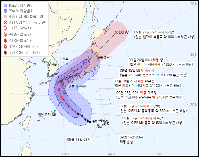
At 9 p.m. on the 17th, Nanmadol is expected to develop to a central pressure of 915 hPa and reach 'super typhoon' strength, then turn eastward from the 18th and reach the sea about 130 km southwest-southwest of Kagoshima by 9 p.m. The 'very strong' typhoon intensity corresponds to maximum wind speeds of 44?54 m/s, while 'super typhoon' strength is defined as maximum wind speeds exceeding 54 m/s. Nanmadol is passing over a high sea surface temperature area (29?30 degrees Celsius), receiving moisture supply and developing vertically without obstacles, causing it to intensify very rapidly in a short time.
Park Jung-hwan, a forecaster and analyst at the KMA, said, "From dawn to daytime on the 19th, when the typhoon is closest, strong winds will blow mainly over Jeju Island, the coastal areas of Gyeongsang Province, and the East Coast. There is a possibility that typhoon warnings will be issued for Jeju and the coastal areas of Gyeongsang Province on the 18th and 19th." He added, "On the night of the 18th, Jeju, early morning of the 19th, the coastal areas of Gyeongsang Province and Gyeongsangnam-do, and from morning to daytime on the 19th, the southern coastal areas of eastern Gyeongbuk are expected to fall within the typhoon's strong wind radius."
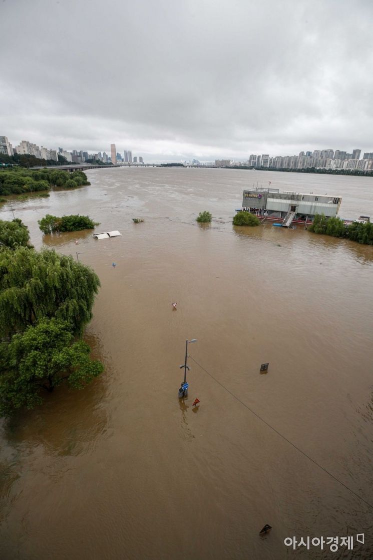 Due to the impact of Typhoon No. 11 'Hinnamnor', heavy rain is falling, and the Seoul Hangang Park walking trail is flooded on the 6th. Photo by Jinhyung Kang aymsdream@
The time when the typhoon will be closest to the Korean Peninsula is between dawn and daytime on the 19th, with rainfall forecasted to reach 30?60 mm per hour over Jeju and the coastal areas of Gyeongsang Province. Expected precipitation from the 18th to the 19th is over 150 mm in the coastal areas of Gyeongsang Province; 50?100 mm in the coastal areas of Gyeongsang Province, Gangwon Yeongdong, and mountainous areas of Jeju; 20?80 mm in the eastern inland areas of Gyeongsang Province and Jeju; and 5?40 mm in eastern Jeolla and western inland areas of Gyeongsang.
From the 18th, Jeju Island and the coastal areas of Gyeongsang Province will fall within the typhoon's strong wind radius (areas experiencing winds of 15 m/s or more), with maximum instantaneous wind speeds expected to reach 25?35 m/s. Starting from the 17th in the distant sea of the South Sea, high waves up to 10 meters are expected in the South Sea and East Sea until the 19th. Storm surges are likely along the coast of Jeju Island, and wave overtopping is highly possible along the southern and eastern coasts. Swell waves will continue along the East Coast until the 20th.
The typhoon is moving along the edge of the North Pacific high pressure system and is currently expected to pass north of Kyushu and move along the northern coast of Kyushu, but there remains a possibility of some adjustment in its path depending on the influence of pressure systems. If the typhoon's path shifts toward the Korea Strait, the amount, intensity, and area of rainfall may increase. Conversely, if it moves southward toward Kyushu, the amount, intensity, and area of rainfall are expected to decrease.
Forecaster Park explained, "We expect Nanmadol to develop into a super typhoon between tonight and early morning on the 18th. With a strong wind radius reaching 400 km, even if the typhoon passes north of Kyushu, the Gyeongsang region of our country will fall within the strong wind radius, so caution is necessary."
© The Asia Business Daily(www.asiae.co.kr). All rights reserved.
![Clutching a Stolen Dior Bag, Saying "I Hate Being Poor but Real"... The Grotesque Con of a "Human Knockoff" [Slate]](https://cwcontent.asiae.co.kr/asiaresize/183/2026021902243444107_1771435474.jpg)


