Over 500mm of Rainfall Recorded in the Seoul Metropolitan Area Over Two Days
More Rainfall Than During the Umyeonsan Landslide
9 Deaths and 7 Missing Reported Due to Heavy Rain
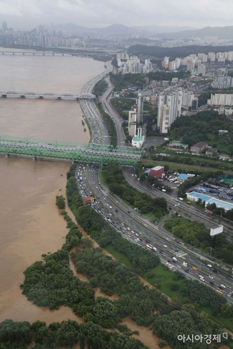 On the 9th, when record-breaking heavy rain fell mainly in the central region including Seoul, vehicles were moving slowly on Olympic-daero as seen from the 63 Square Observatory in Yeouido. From 2:30 PM, vehicle traffic in both directions on Olympic-daero between Gayang Bridge and Dongjak Bridge resumed. The Seoul Metropolitan Government announced, "We have fully reopened vehicle traffic in the section that was controlled due to increased discharge from Paldang Dam." / Photo by Moon Honam munonam@
[Asia Economy Reporter Han Jinju] A stationary front is moving southward, bringing very heavy rain mainly to the Chungcheong region on the 10th. The rain clouds will temporarily clear in the Seoul metropolitan area and Gangwon Province, where heavy rain fell over the past two days.
According to the Korea Meteorological Administration on the 10th, more than 300mm of heavy rain is expected mainly in the Chungcheong region until the 11th. The Chungcheong region, inland Gyeongbuk, and northern Jeonbuk are expected to receive 100?200mm, southern Gyeonggi and southern Yeongseo in Gangwon, southern Jeonbuk, and Ulleungdo·Dokdo 50?150mm, and Seoul, Incheon, northern Gyeonggi, Gangwon Province (except southern Yeongseo), and Gyeongbuk region (except northern inland) about 20?80mm of rain.
The Chungcheong region is experiencing very heavy rain at a rate of 30?50mm per hour, while other areas are seeing around 10mm per hour. Heavy rain warnings are in effect for southern inland and mountainous areas of Gangwon, Chungcheong region, northwestern inland Gyeongbuk, and northern Jeonbuk. Heavy rain alerts have been issued for Sejong, Daejeon, and parts of Chungbuk and Chungnam.
In the Seoul metropolitan area and Yeongseo region of Gangwon, the rain will briefly stop on the 10th but will be affected again on the 11th as the stationary front moves northward. On the 12th, the stationary front will move southward again, bringing heavy rain mainly to southern Chungcheong, Jeonbuk, and northern Gyeongbuk.
From the 8th to the morning of the 10th, over 500mm of rain fell in Seoul, Gyeonggi, and Yeongseo region of Gangwon. As of 9 a.m. on the 10th, cumulative rainfall amounts were 532.5mm at Yongmunsan (Yangpyeong), 525mm at the Meteorological Administration (Seoul), 524.5mm in Gwangju, Gyeonggi, 495mm at Sanbuk (Yeoju), 365mm at Cheongil (Hoengseong), 356.5mm at Sidong (Hongcheon), and 258.5mm in Seoul.
The maximum hourly rainfall record over two days far exceeded the hourly rainfall of 113mm recorded in Namhyeon during the Umyeonsan landslide. On the 8th at 9 p.m., Seoul recorded 136.5mm, Gwangmyeong, Gyeonggi 109.5mm, and at midnight on the 9th, Seongnam, Gyeonggi recorded 91.5mm. The highest hourly rainfall ever recorded was 145mm in Juam on July 31, 1998, and the highest one-hour rainfall in Seoul was 118.6mm on August 5, 1942.
The prolonged heavy rain over two days has also increased casualties and property damage. According to the Central Disaster and Safety Countermeasures Headquarters (CDSCH), there have been 9 deaths, 7 missing persons, and 17 injuries. On the 9th, a landslide buried a house in Hoengseong, resulting in one death, and a teenager was swept away and went missing in a river in Namyangju, Gyeonggi Province. There are 570 disaster victims and 1,253 people temporarily evacuated. Flood damage to houses and commercial buildings totaled 2,676 structures, with damage concentrated in Seoul (2,419 buildings).
This rainfall was caused by a blocking low-pressure system that disrupted airflow, guiding cold and dry air from the west southward, while hot and humid air from the south flowed in, creating very strong rain clouds. The cloud band, narrow north-south and long east-west, moves up and down north-south, producing heavy rain. Depending on the position of the stationary front, there is significant variability in rainfall amounts and affected areas.
Woo Jin-gyu, a forecaster and analyst at the Korea Meteorological Administration, said, "As the stationary front moves southward, the damage is likely to expand to the southern regions," and urged, "All regions including Chungcheong, Jeonbuk, and Gyeongbuk should prepare carefully for damage caused by heavy rain such as flooding, road congestion, property damage, and embankment collapse."
© The Asia Business Daily(www.asiae.co.kr). All rights reserved.
![Clutching a Stolen Dior Bag, Saying "I Hate Being Poor but Real"... The Grotesque Con of a "Human Knockoff" [Slate]](https://cwcontent.asiae.co.kr/asiaresize/183/2026021902243444107_1771435474.jpg)


