Moving northward along the edge of the North Pacific High by the shortest route
Expected to pass east or west of Jeju Island
[Asia Economy Reporter Han Jinju] Typhoon Aere, the fourth typhoon of the season, is rapidly moving north and is expected to affect Jeju Island and the southern coast of Korea on the 4th and 5th.
On the 1st, the Korea Meteorological Administration (KMA) stated in a briefing that Typhoon Aere, which formed on the 5th of the month, will begin to impact the southern seas of Jeju Island starting on the 3rd, and will mainly affect Jeju Island and the southern coast from the 4th to the 6th.
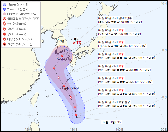
Typhoon Aere formed at 9 a.m. on the 1st, located 760 km south-southeast of Okinawa, Japan, moving north-northeast at 13 km/h. The central pressure is 1002 hPa, and the maximum wind speed is 18 m/s.
Aere is expected to move north along the edge of the North Pacific High, taking the shortest route northward.
It is predicted to reach 260 km north-northwest of Okinawa by 9 a.m. on the 3rd, then 260 km south-southwest of Seogwipo City, Jeju Island by 9 a.m. on the 4th, and pass 190 km southwest of Busan by 9 a.m. on the 5th.
Forecaster Park Jung-hwan said, "The tropical depression rapidly developed into a typhoon early on the 1st, with strong winds and a large amount of moisture inflow, so heavy rainfall is expected. There is a possibility of damage mainly around Jeju Island and the southern coast, so preparations are necessary."
Although the typhoon is expected to pass either west or east of Jeju Island, the situation is highly variable. From the 3rd to the 5th, when Aere moves north toward Korea, there are significant differences in the typhoon's intensity and path depending on the numerical forecast models.
Forecaster Park explained, "Because the typhoon is small in size, it is greatly influenced by surrounding environmental factors such as pressure systems and sea surface temperatures, resulting in high variability. Both the west and east of Jeju Island fall within the 70% probability radius of the typhoon's location."
On the 4th and 5th, as the typhoon moves north under the stationary front, heavy rain is expected due to the typhoon's influence rather than the usual monsoon rain. Initially, the KMA forecasted that a tropical low-pressure vortex would approach the southern sea on the 4th and 5th, activating the stationary front.
The monsoon is expected to affect the region again after the typhoon passes on the 5th.
Forecaster Park said, "The stationary front is located north of North Korea, and the high-pressure system is temporarily expanding, so it is difficult to say that the influence of the stationary front has completely ended. After the typhoon passes on the 5th, when the pressure systems reorganize, there is a possibility that the stationary front will be reactivated."
© The Asia Business Daily(www.asiae.co.kr). All rights reserved.
![Clutching a Stolen Dior Bag, Saying "I Hate Being Poor but Real"... The Grotesque Con of a "Human Knockoff" [Slate]](https://cwcontent.asiae.co.kr/asiaresize/183/2026021902243444107_1771435474.jpg)


