A pilot project is being promoted to discover drone routes and expand the scope of drone utilization such as blood delivery, disaster response, and facility safety management.
On the 13th, the Ministry of Land, Infrastructure and Transport announced that it had selected seven project operators including the Korea Land and Geospatial Informatix Corporation, Korea Airports Corporation, and KT for the 'K-Drone System' pilot project.
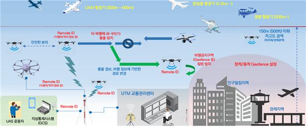
The K-Drone System is a drone traffic management system that performs functions such as flight plan approval, location information monitoring, and collision avoidance with surrounding flying objects.
The pilot project operators will seek ways to apply the technologies developed through the K-Drone System research and development (R&D) project to real-life areas and will demonstrate the operation of the traffic management system essential for expanding the business scope.
The pilot project will be conducted in a total of five fields where commercialization potential is high and safety assurance is necessary: ▲urban and flight routes ▲airports and special facilities ▲public ▲private ▲open call.
In the urban and flight route field, the Korea Land and Geospatial Informatix Corporation will discover safe drone routes equipped with drone traffic management functions to realize drone shooting work for acquiring land information and address-based delivery services.
In the airport and special facilities field, the traffic management function for using drones in disaster response near national facilities (aeronautical radio navigation facilities) (Korea Airports Corporation) and the method of linking with the manned and unmanned aircraft traffic control system used by the Army (KT) will be demonstrated.
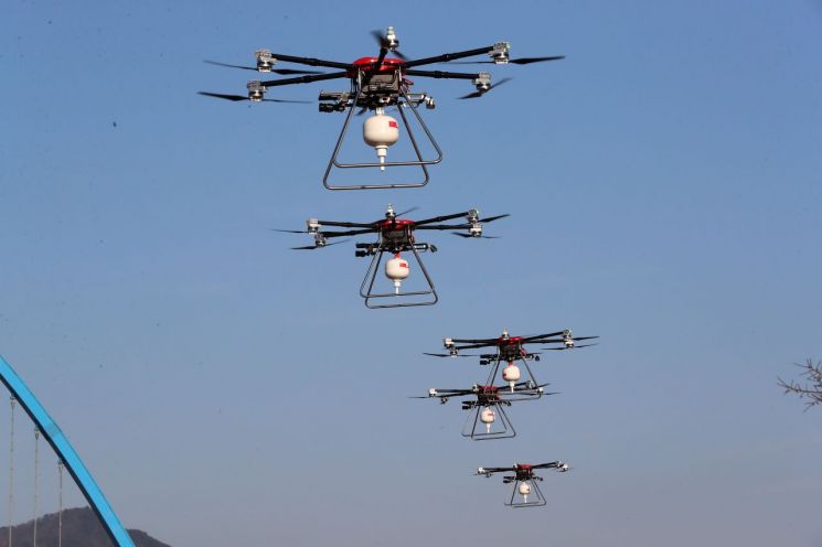
In the public field, a project management model for the safe management of nationally important facilities such as water systems, dams, and water intake facilities (K-water) and beyond visual line of sight flight for blood delivery over a distance of about 7.8 km between the Korean Red Cross Chungbuk Chapter and Osong Bestian Hospital (Hancom Inspace) will be demonstrated.
In the private field, a demonstration adding drone traffic management functions to a long-distance drone video shooting business model for progress management of highway construction sections (SysTech) will be conducted, and in the open call field, drone traffic management procedures for safe flight of various drone types in the waters around Yeongdo, Busan (Marine Drone Technology) will be demonstrated.
Through this project, it is expected that the discovery of 'specific purpose (delivery, shooting, surveillance, etc.) drone routes' in urban areas, drone management around nationally important facilities, and commercialization of drone traffic management services will accelerate.
Also, through the special facilities field added this year, it is expected that demonstration data on regional security and safety will be accumulated to prepare safety measures in response to the increase in drone traffic.
Najin Hang, Future Drone Traffic Officer at the Ministry of Land, Infrastructure and Transport, said, "A drone traffic management system is essential for multiple drones to fly long distances," adding, "We expect that drone utilization projects, which have been promoted on a pilot basis so far, will be commercialized through drone traffic management services."
© The Asia Business Daily(www.asiae.co.kr). All rights reserved.


