Remaining Signal Time, Pedestrian and Hazard Alerts Integrated into Public Transportation Information and Private Navigation Technology
Agreement Signed for 623 Intersections in Sadaemun and Gangnam, 22 Roads...
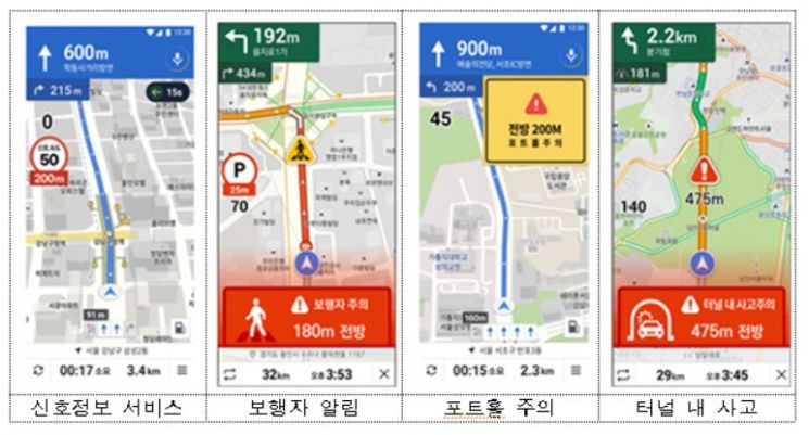
[Asia Economy Reporter Lim Cheol-young] On the 28th, the Seoul Metropolitan Government announced that it will pilot operate a Connected Driving Service, which links public traffic information such as traffic signals, road hazards, and construction information collected independently through the next-generation intelligent transportation system C-ITS, to private navigation services like Kakao Mobility and T map starting at the end of this year.
The Connected Driving Service connects vehicle-to-vehicle (V2V) and vehicle-to-infrastructure (V2I) to exchange mutual hazard information, drastically reducing traffic accidents and supporting safe driving. It provides additional information such as whether the traffic light has changed during driving, how much time remains on the signal, whether pedestrians are crossing at intersections, and whether there are hazards like road collapses ahead, offering a higher level of navigation guidance to alert drivers and prevent accidents.
Accordingly, to provide stable service to a large number of users, Seoul selected navigation companies Kakao Mobility and T map, each with over ten thousand navigation app users, as pilot service operators and signed an inter-agency agreement. The pilot operation service will start at the end of this year in the downtown area (inside the Four Great Gates) and expand by March next year to 22 roads (151.0 km) including Yeouido, Gangnam, Sangam-dong, and central bus-only lanes such as Yanghwa and Sinchon roads, covering a total of 623 locations (intersections). Seoul plans to gradually expand real-time traffic information services citywide by 2024.
Through the business agreement, navigation companies will also provide traffic usage information to the city. When navigation companies provide de-identified origin and destination data and intersection usage information in downtown Seoul, the city will utilize this data to analyze vehicle intersection movement patterns and apply it to optimize signal operations, thereby improving the urban traffic environment based on data.
Baek Ho, Director of Urban Transportation at Seoul City, said, "This pilot service is a desirable model of public-private cooperation that actively provides real-time public traffic information to the private sector and improves citizen convenience by integrating private technology." He added, "Starting with this pilot service, we will actively strive to become a ‘Smart Transportation Leading City’ planned in ‘Seoul Vision 2030’ by expanding autonomous vehicle pilot zones, expanding autonomous driving infrastructure, and introducing new transportation modes."
© The Asia Business Daily(www.asiae.co.kr). All rights reserved.
![Clutching a Stolen Dior Bag, Saying "I Hate Being Poor but Real"... The Grotesque Con of a "Human Knockoff" [Slate]](https://cwcontent.asiae.co.kr/asiaresize/183/2026021902243444107_1771435474.jpg)


