Passing 80km southeast off Seogwipo, crossing the Korea Strait in the afternoon
Jeju 50~80mm/hr, Gyeongnam coastal areas 30~50mm/hr
Typhoon warnings for Jeju Island, parts of Jeonnam and Gyeongnam, southern West Sea, and South Sea
Over 1000mm rainfall in Jeju mountains since the 13th due to typhoon impact
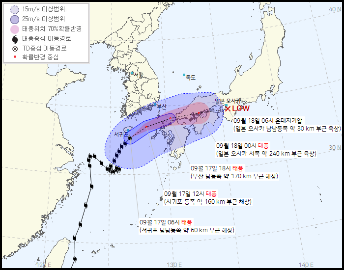
[Asia Economy Reporter Han Jinju] As of the 17th, Typhoon Chantou is passing 80km southeast of Seogwipo and will pass through the Korea Strait in the afternoon. Typhoon warnings have been issued for Jeju and Busan, with Jeju expected to receive heavy rain of about 50 to 80mm per hour.
According to the Korea Meteorological Administration, as of 7 a.m., Typhoon Chantou is moving northeast at 25 km/h and is expected to pass through the Korea Strait between the afternoon and night. The central pressure of Typhoon Chantou is 980 hPa, with maximum wind speeds of 104 km/h.
Currently, typhoon warnings are in effect for Jeju Island, Busan, parts of Jeonnam and Gyeongnam, the seas around Jeju Island, the southern part of the West Sea, and the South Sea. From morning to afternoon, typhoon warnings will expand to some parts of the Gyeongsang region and the East Sea.
Jeju Island will experience very heavy rain accompanied by thunder and lightning, with hourly rainfall of 50 to 80mm until the morning, and the coastal areas of Gyeongnam will see 30 to 50mm per hour during the day. The southern regions and Chungcheong area will also have strong rain of about 20 to 30mm per hour during the day, with the possibility of heavy rain warnings being issued.
Heavy rain will continue mainly in Jeju Island and the southern coast on this day. Rain will also fall in other southern regions, Chungcheong, southern Gyeonggi, and Gangwon Province (excluding Yeongseo). Most of southern Gyeonggi, central and southern Yeongseo in Gangwon, Chungnam, and western Gyeongsang will see rain stop in the afternoon. Rain will continue until night in Chungbuk, northern Gyeongbuk, and the eastern coast of Gyeongsang.
Expected rainfall on the 17th is ▲Jeju 50?100mm (up to 150mm in some areas) ▲Gyeongnam coastal areas 30?80mm (over 120mm in some areas) ▲Chungcheong and Gyeongbuk over 80mm ▲Central and southern Yeongseo in Gangwon, southern regions, Ulleungdo and Dokdo 10?60mm ▲Southern Gyeonggi 5?20mm.
Jeju Island has experienced heavy rain for five consecutive days since the 13th, with cumulative rainfall exceeding 1000mm in some areas. Major rainfall amounts are ▲Jindallaebat (Seogwipo) 1192.0mm ▲Hallasan South Face (Seogwipo) 1018.0mm ▲Witseoreum (Jeju) 994.5mm ▲Samgakbong (Jeju) 937.5mm ▲Seongpanak (Jeju) 839.0mm ▲Seogwipo 509.8mm.
As the typhoon moves north, on the 17th, Jeju Island will experience maximum instantaneous wind speeds of 30 to 50 m/s, the southern coast and eastern coast of Gyeongsang will have 20 to 30 m/s, and other southern regions will have 15 to 25 m/s winds, all very strong. At sea, winds will be very strong at 12 to 26 m/s until the 17th, with waves reaching 2.0 to 8.0 meters, very high.
The Korea Meteorological Administration advised, "Be cautious of damage to outdoor screening clinics, construction site equipment, vinyl greenhouses, wind turbines, and spires, and also be careful of damage to crops during the harvest season." They added, "As the typhoon moves north, winds will gradually strengthen and waves will rise, leading to an expansion or strengthening of storm warnings, and some seas will be upgraded to typhoon warnings. Please prepare to prevent damage."
© The Asia Business Daily(www.asiae.co.kr). All rights reserved.
![Clutching a Stolen Dior Bag, Saying "I Hate Being Poor but Real"... The Grotesque Con of a "Human Knockoff" [Slate]](https://cwcontent.asiae.co.kr/asiaresize/183/2026021902243444107_1771435474.jpg)


