Around 4 PM, near Busan
Exiting to the East Coast near Pohang 2 hours later
Cumulative rainfall expected to reach 150mm by tomorrow
Some areas in Chungcheong and Jeonbuk where stationary fronts merge may exceed 250mm
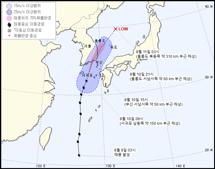
[Asia Economy Reporter Lee Hyun-joo] As the 5th typhoon 'Jangmi (JANGMI)' approaches, typhoon warnings have been issued for the southern coast and Jeju Island.
According to the Korea Meteorological Administration, as of 10 a.m., the typhoon is moving north-northeast at 44 km/h, located 135 km southeast of Seogwipo.
The rain cloud band formed at the front of the advancing Jangmi is moving north at a fast speed of 50 km/h and is expected to be located near the sea off Tongyeong, Gyeongnam around 3 p.m. It is forecasted to be closest to Busan around 4 p.m. and to move out to the East Coast near Pohang around 6 p.m., the KMA said.
The Chungcheong and southern regions, which will be directly affected by the typhoon, are expected to record cumulative rainfall of 50 to 150 mm by tomorrow. Some parts of Chungcheong and Jeonbuk, also affected by the stationary front, are expected to experience very heavy rain exceeding 250 mm. Seoul, Gyeonggi Province, Gangwon Province, and Jeju Island are forecasted to receive 30 to 80 mm of rain, with southern Gangwon receiving over 120 mm, according to the KMA.
Most of the rain will stop by tomorrow afternoon, but it will continue until night in Seoul, Gyeonggi, Gangwon Yeongseo, and Jeolla regions.
© The Asia Business Daily(www.asiae.co.kr). All rights reserved.
![Clutching a Stolen Dior Bag, Saying "I Hate Being Poor but Real"... The Grotesque Con of a "Human Knockoff" [Slate]](https://cwcontent.asiae.co.kr/asiaresize/183/2026021902243444107_1771435474.jpg)


