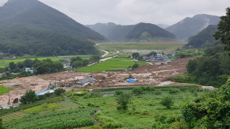
 On the morning of the 8th, additional rescue operations are resuming at the landslide site in Osan-myeon, Gokseong-myeon, Jeonnam. The day before, soil debris buried houses below the mountain, causing casualties. Photo by Yonhap News
[Asia Economy (Daejeon) Reporter Jeong Il-woong] Since the 1st of this month until the 9th, a total of 667 landslides of various sizes have been reported nationwide. The Korea Forest Service has currently raised the landslide crisis alert to the highest level, ‘Severe,’ emphasizing the proactive evacuation of residents in landslide-prone areas in case of emergencies.
According to the Korea Forest Service’s Landslide Prevention Support Headquarters on the 9th, since the 1st, landslides have occurred nationwide as follows: ▲Chungbuk 314 cases ▲Gyeonggi-do 131 cases ▲Chungnam 97 cases ▲Gangwon-do 72 cases ▲Gyeongbuk 34 cases ▲Gyeongnam 18 cases ▲Jeonbuk 1 case.
In particular, during the previous day alone, 55 landslides were recorded due to heavy rain in areas including Anseong, Yeoncheon, Gapyeong, and Gimpo in Gyeonggi; Cheorwon, Hongcheon, Inje, and Wonju in Gangwon; and Geochang, Hapcheon, Sancheong, and Hamyang in Gyeongnam.
Accordingly, as of 12 PM the previous day, the Korea Forest Service expanded the landslide crisis alert ‘Severe’ to 16 cities and provinces nationwide, excluding Jeju Island, and as of 7 AM on the 9th, issued landslide forecasts (warnings and advisories) to 81 cities, counties, and districts nationwide.
The ‘Warning’ was issued to 24 locations including ▲Busan (Suyeong) ▲Gwangju (Buk) ▲Sejong ▲Gyeonggi (Gapyeong, Anseong) ▲Chungbuk (Okcheon) ▲Jeonbuk (Namwon, Muju, Imsil, Jangsu, Jinan) ▲Jeonnam (Gokseong, Gwangyang, Gurye, Suncheon, Hwasun) ▲Gyeongbuk (Seongju) ▲Gyeongnam (Geochang, Sancheong, Uiryeong, Jinju, Hadong, Hamyang, Hapcheon).
The ‘Advisory’ was issued to 57 locations including ▲Incheon (Ganghwa, Ongjin) ▲Daegu (Dalseong) ▲Gwangju (Dong) ▲Gyeonggi (Goyang, Gwacheon, Gwangmyeong, Gwangju, Guri, Gunpo, Gimpo, Namyangju, Dongducheon, Bucheon, Seongnam, Suwon, Siheung, Ansan, Anyang, Yangju, Yangpyeong, Yeoju, Yeoncheon, Osan, Yongin, Uiwang, Uijeongbu, Icheon, Paju, Pyeongtaek, Pocheon, Hanam, Hwaseong) ▲Gangwon (Yeongwol) ▲Chungbuk (Boeun, Yeongdong) ▲Chungnam (Nonsan, Buyeo, Seocheon) ▲Jeonbuk (Gunsan) ▲Jeonnam (Gangjin, Naju, Damyang, Muan, Yeongam, Jangheung, Hampyeong) ▲Gyeongbuk (Gumi, Gimcheon, Yeongyang, Yeongju, Pohang) ▲Gyeongnam (Miryang, Sacheon, Changnyeong, Changwon, Haman).
The Korea Forest Service is maintaining a 24-hour emergency duty system while closely monitoring the ‘Tank Model (landslide prediction system)’ of the landslide information system, which uses accumulated rainfall and ultra-short-term precipitation forecasts provided by the Korea Meteorological Administration, and is fully responding to landslide disasters through close cooperation with local governments, regional offices, and related agencies.
Additionally, in preparation for nationwide heavy rain, emergency inspections of landslide-prone areas are being continuously conducted, and various methods such as emergency disaster messages, subtitle broadcasts, and village broadcasts are being utilized to minimize landslide damage.
Park Jong-ho, Administrator of the Korea Forest Service, said, “With heavy rain falling across the country saturating the soil in the mountains, the possibility of large-scale landslides occurring even with a small amount of rain is currently high,” and added, “We urge the public to evacuate promptly if they receive emergency disaster messages or notice any signs of landslide risk.”
© The Asia Business Daily(www.asiae.co.kr). All rights reserved.
![Clutching a Stolen Dior Bag, Saying "I Hate Being Poor but Real"... The Grotesque Con of a "Human Knockoff" [Slate]](https://cwcontent.asiae.co.kr/asiaresize/183/2026021902243444107_1771435474.jpg)


