Heavy Snow Blankets Jeolla and Jeju, Over 14cm Overnight
Cold Wave Expected... Wind Chill to Plunge
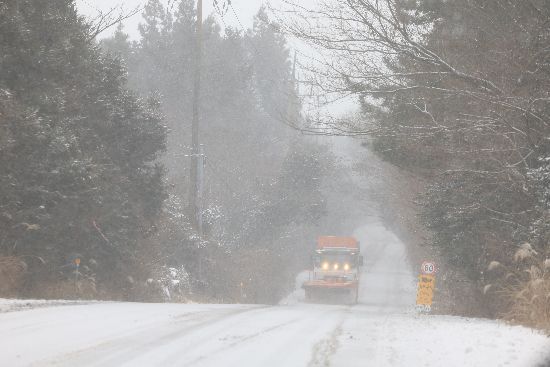
Roads Icy and Hazardous?Caution Advised for Traffic and Safety
On Sunday, January 11, heavy snowfall is expected to mainly affect the Jeolla region and Jeju Island, with a cold wave forecast to sweep across the country.
In the afternoon, most of the snow is expected to stop in South Chungcheong, the Jeolla region, and the western inland areas of South Gyeongsang, while Jeju Island is expected to continue experiencing snow until the early morning of January 12.
In Daejeon, Sejong, and southern North Chungcheong, snow is expected between the morning and midday; in Gyeongsangbuk-do southern inland and the rest of Gyeongsangnam-do except for the western inland, snow is expected between the morning and afternoon; and in the southern coastal areas of Gyeonggi Province, snow is expected in the afternoon.
The expected snowfall is 5 to 15 centimeters (more than 20 centimeters in some areas) in Gwangju, South Jeolla, North Jeolla, the mountainous areas of Jeju Island, Ulleungdo, and Dokdo; 3 to 8 centimeters in the southern coastal areas of South Chungcheong and the western inland of South Gyeongsang; 2 to 7 centimeters in Daejeon, Sejong, South Chungcheong, North Chungcheong, the eastern southern coast of South Jeolla, and the mid-mountain areas of Jeju Island; 1 to 5 centimeters on the coast of Jeju Island; and less than 1 centimeter in the Seoul metropolitan area.
The expected precipitation is 5 to 20 millimeters in Jeju Island, Ulleungdo, and Dokdo; 5 to 15 millimeters in Gwangju, South Jeolla, and North Jeolla; 5 to 10 millimeters in the Chungcheong region; and less than 5 millimeters in the eastern southern coast of South Jeolla and the five West Sea islands.
In particular, heavy snowfall is a concern for Gwangju, South Jeolla, North Jeolla, and the mountainous and mid-mountain areas of Jeju Island. From early morning to midday, intense snowfall of 1 to 3 centimeters per hour (more than 5 centimeters per hour in some places) is expected. In these areas, more than 14 centimeters of snow had already accumulated overnight.
In areas experiencing rain or snow, strong winds and thunder and lightning are also expected. Extra caution is advised for facility management and safety accidents.
The cold wave is also expected to return. The morning low temperature is forecast to be between -15 and -3 degrees Celsius, and the daytime high between -7 and 4 degrees Celsius, which is lower than the average for this time of year (morning -12 to 0 degrees, daytime 0 to 8 degrees).
Cold wave advisories have been issued for the central region, North Jeolla, the coast of South Jeolla, the southern coast of South Gyeongsang, and some inland and mountainous areas of North Gyeongsang. Morning temperatures are expected to drop sharply by 5 to 8 degrees compared to the previous day, and strong winds will make it feel even colder.
The fine dust concentration is forecast to be at a 'good' level nationwide. Wave heights are expected to be 1.0 to 4.0 meters in the East Sea, 1.0 to 5.0 meters in the West Sea, and 0.5 to 3.5 meters in the South Sea.
In the open sea (about 200 kilometers from the coastline), wave heights are expected to reach 2.0 to 5.5 meters in the East Sea, 1.5 to 5.0 meters in the West Sea, and 2.0 to 5.0 meters in the South Sea.
© The Asia Business Daily(www.asiae.co.kr). All rights reserved.
![Clutching a Stolen Dior Bag, Saying "I Hate Being Poor but Real"... The Grotesque Con of a "Human Knockoff" [Slate]](https://cwcontent.asiae.co.kr/asiaresize/183/2026021902243444107_1771435474.jpg)


