Korea Meteorological Administration Issues Cold Wave Advisory as of 9 p.m. on December 25
On December 25, Christmas Day, the first cold wave warning of this winter was issued.
As of 9 p.m. that night, the Korea Meteorological Administration issued a cold wave advisory. In some areas of northern Gyeonggi, Gangwon, Chungbuk, and Gyeongbuk, a higher-level cold wave warning was put in place. This is the first time this winter that a cold wave warning has been issued.
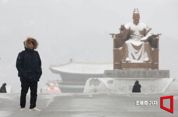 Amidst the severe cold, heavy snowfall occurred in the Seoul area the previous day, and on the morning of the 7th, snow covered the statue of King Sejong at Gwanghwamun Square in Seoul. The Korea Meteorological Administration forecasted that the cold wave would persist nationwide until the weekend. February 7, 2025 Photo by Jo Yongjun
A cold wave advisory is issued when the morning low temperature remains at or below -12 degrees Celsius for two or more days, or when a sudden drop in temperature is expected to cause significant damage. The criteria for a cold wave warning are when the morning low temperature stays at or below -15 degrees Celsius for two or more days, or when a sudden cold snap is expected to cause significant damage over a wide area.
According to the Korea Meteorological Administration, as strong cold air flows in from the northwest, the morning temperature in the Seoul metropolitan area on the 26th is expected to drop to -16 degrees Celsius, marking the coldest day of this winter. In Seoul, the morning temperature on the 26th is forecast to fall to -12 degrees Celsius, and some parts of the metropolitan area are expected to record -16 degrees Celsius.
With strong winds accompanying the cold, the perceived temperature will drop even further. In Seoul, the wind chill is expected to reach -18 degrees Celsius, and in northern Gyeonggi, it could fall as low as -23 degrees Celsius, making it the harshest cold spell of this winter.
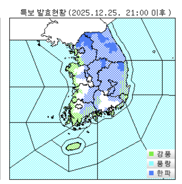
Strong wind advisories have been issued for coastal regions and Jeju Island, where high winds are expected. The Korea Meteorological Administration cautioned, "Starting today (the 25th), strong winds will make it feel even colder, so please take extra care to protect your health against the sharp temperature drop and low temperatures."
Snow fell mainly along the southern west coast and Jeju Island on this day, and from the afternoon until the morning of the 26th, heavy snowfall of around 1 cm per hour is expected to be concentrated in the Jeolla west coast and the mid-mountain and mountainous areas of Jeju Island. Heavy snow advisories have already been issued for these regions.
By the 26th, expected snowfall is 1 to 5 cm for the west coast of Chungnam and western Gwangju, 3 to 8 cm for the Jeolla west coast, and more than 10 cm could accumulate on the Jeonbuk west coast where snowfall will be heaviest. Up to 15 cm is forecast for Hallasan Mountain in Jeju, and Ulleungdo could see as much as 30 cm of snow.
An official from the Korea Meteorological Administration stated, "Due to heavy snowfall, there is a possibility that vehicles could become stranded, so please check traffic conditions in advance and thoroughly prepare winter equipment if you plan to drive."
© The Asia Business Daily(www.asiae.co.kr). All rights reserved.
![Clutching a Stolen Dior Bag, Saying "I Hate Being Poor but Real"... The Grotesque Con of a "Human Knockoff" [Slate]](https://cwcontent.asiae.co.kr/asiaresize/183/2026021902243444107_1771435474.jpg)


