Mercator Projection World Maps Distort the Southern Hemisphere
African Nations Lead the "Correct the Map" Campaign
"The Oldest Disinformation in the World Must Be Stopped"
There are growing calls from African nations for the international community to adopt maps that accurately reflect the true size of the African continent. According to Yonhap News, citing the British daily The Times on August 15 (local time), the "Correct the Map" campaign-led by organizations such as "Africa No Filter" and "Speak Up Africa"-has recently gained official support from the African Union (AU), thereby increasing its international influence.
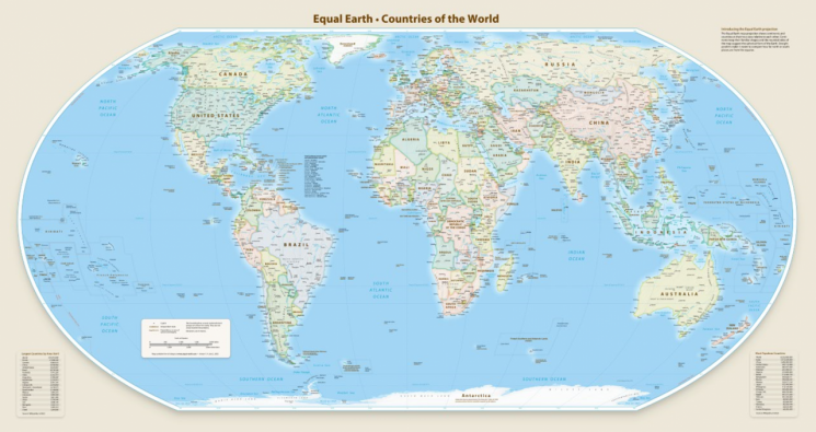 The "Equal Earth" world map, regarded as the most accurate representation of the actual area of countries and continents. The African continent is positioned at the center. Official Equal Earth website
These groups argue that international organizations, including the United Nations (UN) and the World Bank, should adopt the "Equal Earth" map, developed in 2018, instead of the current maps based on the Mercator projection. The Equal Earth map is regarded as the most accurate representation of the actual area of countries and continents.
The flat world maps currently used in classrooms, atlases, and digital mapping services worldwide are based on the Mercator projection, which was created in 1569 by Dutch cartographer Gerardus Mercator. This method involves placing the Earth inside a large cylinder and projecting light from the Earth's center, drawing the resulting image onto the cylinder. Due to the distance from the light source, the Northern Hemisphere appears larger while the Southern Hemisphere appears smaller.
This results in Greenland, which is close to the Arctic, appearing almost as large as, or even larger than, Africa, which straddles the equator. However, Greenland's actual area is only about one-fourteenth that of Africa. In reality, Africa is a vast continent, accounting for 20.4% of the Earth's land area. Including surrounding islands, it covers 30.37 million square kilometers. This is twice the size of Russia, the world's largest country, which has an area of about 17.1 million square kilometers. In contrast, Greenland's area is approximately 2.16 million square kilometers. The Times explained, "Africa is so large that it could contain the United States, China, India, Japan, and most of Western Europe combined."
Selma Hadadi, a member of the AU Executive Council, stated, "The distortion (of the map) is not merely a geographic issue," adding, "It diminishes Africa's significance in the world and reinforces prejudice and stereotypes." Moki Makura, Executive Director of Africa No Filter, also said, "The world maps currently in use misrepresent the size of Africa," and described this as "the oldest disinformation campaign in the world, which must come to an end."
© The Asia Business Daily(www.asiae.co.kr). All rights reserved.


