AI Restoration Model Developed for Satellite Sea Surface Temperature Data
Enhancing Reliability of Predictions for High Sea Temperatures and Typhoons
Published in Remote Sensing of Environment
Every summer, typhoons that threaten the Korean Peninsula draw their strength from the warm waters of the Northwest Pacific Ocean.
Recently, extreme weather events such as heat waves and droughts have also been linked to high sea surface temperatures, further highlighting the importance of accurate sea surface temperature predictions.
To enhance the reliability of such predictions, accurate historical observation data is essential. Now, an artificial intelligence model has been developed to restore missing intervals in satellite measurements.
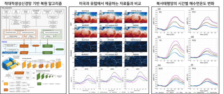
On June 19, a research team led by Professor Lim Jeongho from the Department of Urban and Environmental Engineering at UNIST announced the development of an AI restoration model that can reconstruct sea surface temperature data at one-hour intervals and with 2-kilometer spatial resolution, by supplementing missing sections in satellite observation networks.
 Research team, Professor Lim Jeongho (left) and first author researcher Jung Sihoon. Provided by UNIST
Oceans store 90% of the Earth's heat energy. Among them, the sea surface is the point where heat energy is directly exchanged between the ocean and the atmosphere. When the sea surface warms, this heat energy is transferred to the air, potentially causing phenomena such as typhoons, heat waves, and heavy rainfall.
Satellite observation offers the advantage of monitoring sea surface temperatures over wide areas. However, spatial and temporal gaps frequently occur due to factors such as clouds, precipitation, and limitations in observation angles. These gaps make it difficult to track changes in sea surface temperature and pose limitations to long-term and accurate temperature predictions.
The research team trained a GAN artificial intelligence model using high-frequency satellite observation data and thermodynamic knowledge from numerical forecast models, enabling the restoration of missing intervals in satellite data. While GANs are typically used for image generation, in this study, the model was designed to also learn thermodynamic information from numerical forecast models, allowing it to more precisely reconstruct sea surface temperature data that matches actual oceanic physical conditions.
First author researcher Jung Sihoon explained, "Traditional numerical forecast models or statistical methods struggled to maintain the original resolution of satellite data and required high computational costs. In actual experiments, this model demonstrated higher restoration accuracy than conventional linear interpolation or statistical models, and showed excellent predictive performance even in areas with rapid temperature changes."
Professor Lim Jeongho stated, "The AI-based restoration technology we developed can generate high-resolution sea surface temperature data in the Northwest Pacific, a region with frequent typhoons and high climate variability. Since this area directly affects the climate of the Korean Peninsula, we expect this technology will significantly improve the precision of weather forecasts and climate analysis, and that it can also be used in the long term to respond to marine disasters such as high-temperature events."
The research results were published on June 1 in 'Remote Sensing of Environment' (Impact Factor 11.1), the top international journal in the field of remote sensing. RSE is recognized as a leading journal that shapes global trends in environmental science and satellite observation research.
© The Asia Business Daily(www.asiae.co.kr). All rights reserved.


