On May 27, Incheon City announced that it will be the first local government in the country to launch a project to build a 3cm-class high-resolution 3D public map using drones.
This project will secure imaging data exclusively through drones instead of aircraft, enabling a significantly higher resolution compared to conventional satellite images or aerial photographs and allowing for rapid data updates. In addition, the cost has been reduced to one-fifth of the traditional methods, making it possible to operate the service more efficiently.
Since 2019, the city has been carrying out spatial information data construction projects every other year and is currently providing a 3D virtual city service that accurately depicts even the shapes of building rooftops.
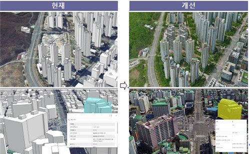
Through this project, which will continue until November, the city plans to maintain the strengths of its existing data while enhancing realism by three-dimensionally rendering building exteriors based on actual captured images.
As a result, it is expected that Incheon will be able to provide citizens with a top-tier, competitive service?on par with or superior to 3D map services offered by other local governments nationwide, as well as private services such as Google and Naver.
An official from Incheon City stated, "We hope that by providing citizens with high-quality 3D map services, public maps will play a key role in various fields."
© The Asia Business Daily(www.asiae.co.kr). All rights reserved.


