Independent Spatial Analysis of Wildfire-Affected Areas
Significant Reduction in Budget and Time
Ulsan Ulju County announced on the 16th that it has achieved significant results by utilizing a Geographic Information System (GIS) for the damage assessment and analysis of the large-scale wildfires in Onyang and Eonyang.
Ulju County independently conducted spatial analysis of the wildfire-affected areas in Onyang and Eonyang, which cover an area of 1,000 hectares, significantly reducing costs and enabling rapid investigation and analysis of wildfire damage.
Previously, Ulju County has been conducting aerial imaging and GPS surveys without complex procedures or additional costs, based on its spatial information-based administrative support project, 'Space Dadeumi,' which has been underway since 2016.
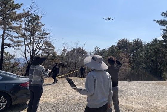 Ulju County, Effectiveness of 'Spatial Information System' in Investigating Forest Fire Damage. Provided by Ulju County
If the wildfire damage assessment and analysis were outsourced to an external company, the minimum service fee (8 million KRW per 1 km²) would require a budget of at least 80 million KRW.
In addition, it usually takes at least four days to complete the administrative procedures to obtain drone flight permits and shooting approvals, and various steps related to budget allocation and service contracts make it difficult to conduct timely investigations.
In contrast, Ulju County, by utilizing its own system, secured flight permits and shooting approvals for the entire region in advance at the beginning of the year, completing aerial imaging of the wildfire-affected areas within three days and efficiently handling practical tasks through collaboration among internal departments.
The analysis results are provided to the Forest Recreation Division, the department in charge of forest management, and are used for identifying the extent of the damage, establishing restoration plans, allocating budgets, and overall recovery response.
An Ulju County official stated, "Systematic response based on spatial information proved highly effective during this wildfire damage assessment," and added, "We will do our utmost to protect the safety and property of Ulju County residents through digital-based administration."
Ulju County is responding to changing administrative demands by integrating administrative information with a focus on spatial data, and is making efforts to enhance the expertise of public officials by encouraging drone certification and providing GIS program training.
© The Asia Business Daily(www.asiae.co.kr). All rights reserved.


