Clear Burn Scars Captured by NASA's Earth Observation Satellite Landsat 9
From Uiseong Through Andong to Yeongdeok
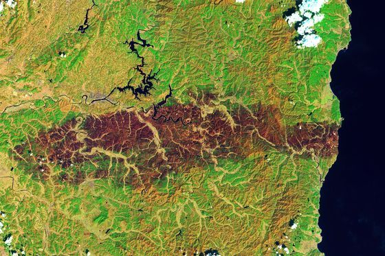
At the end of last month, a massive wildfire that burned the Gyeongbuk region for over a week left scars captured by a NASA satellite. On the 8th (local time), NASA's official website Earth Observatory posted satellite images of the Gyeongbuk wildfire damage area taken by the Earth observation satellite Landsat 9. These satellite images were taken on the 4th and show the burn scars stretching about 80 km from the initial ignition point in Uiseong-gun through Andong, Cheongsong, Yeongyang-gun, to Yeongdeok-gun, where the forest turned dark from the fire.
 A massive wildfire that broke out at the end of last month and burned the Gyeongbuk region for over a week was captured by a NASA satellite. On the 8th (local time), a satellite image of the wildfire damage area in Gyeongbuk, taken by the Landsat 9 Earth observation satellite, was posted on NASA's official Earth Observatory website. NASA earthobservatory
However, the images are composites created by combining shortwave infrared, near-infrared, and visible light wavelengths, so the colors are not true to life but artificially colored to distinguish burned areas from unburned ones. The damage from this wildfire can also be estimated by the amount of greenhouse gas emissions. When a wildfire occurs, the leaves and branches of trees burn, releasing greenhouse gases including carbon dioxide, and the emissions can be calculated based on the burned area and the amount of forest.
Accordingly, the provisional wildfire impact area is 48,239 hectares, with estimated greenhouse gas emissions of 3,245,000 tons of carbon dioxide, 272,000 tons of methane, and 143,000 tons of nitrous oxide, totaling approximately 3.66 million tons. Among these, Gyeongbuk Province has tentatively estimated the reported wildfire damage amount at 1.43 trillion won. The restoration cost is estimated at 2.7868 trillion won. The reported damage amount and restoration cost estimates refer to the scale of reports entered by cities and counties into the National Disaster Management System (NDMS), based on which central government agencies conduct joint investigations to finalize the damage and restoration costs.
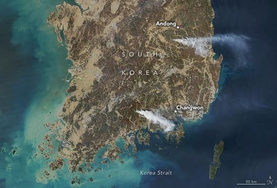 The U.S. National Aeronautics and Space Administration (NASA) posted satellite images dated the 22nd showing the wildfire situation in Korea. NASA Earth Observatory shared photos taken by the AQUA satellite, explaining that "smoke is rising from the fire areas in Uiseong-gun near Andong-si, Gyeongbuk, and Sancheong-gun, Gyeongnam." NASA Earth Observatory Photo by Yonhap News
Meanwhile, the Landsat 9 satellite, launched in 2021, orbits in a polar orbit at an altitude of 700 km, revisiting the same area on Earth every 8 days with a resolution of 30 meters. A polar orbit refers to an orbit that passes over the Earth's North and South Poles, allowing periodic observation of the entire Earth. The satellite's primary mission is to monitor changes on the Earth's surface such as forests, farmland, cities, and coastlines. Landsat is a long-term Earth observation project initiated by the U.S. government in 1972.
© The Asia Business Daily(www.asiae.co.kr). All rights reserved.


