Im Mira, Deputy Director of the Korea Forest Service, Holds Press Briefing
"Fire Line Image Created for Five Cities and Counties"
The Korea Forest Service announced on the 27th that it is utilizing 'integrated drone, airplane, and satellite technology' to effectively respond to the large-scale wildfires that occurred in five cities and counties in the northern Gyeongbuk region, including Uiseong, Andong, Yeongyang, Yeongdeok, and Cheongsong.

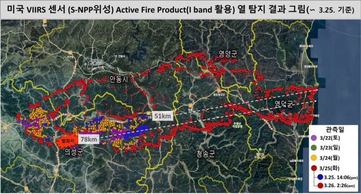
Im Mira, Deputy Director of the Korea Forest Service, held a press briefing at the Government Complex Daejeon on the same day and revealed, "We mobilized mapping drones, infrared detection airplanes, and the Visible Infrared Imaging Radiometer Suite (VIIRS) onboard NASA's Suomi NPP satellite to create an image map of the entire fire line in the northern Gyeongbuk area."
She explained that as the wildfire spread unprecedentedly due to strong winds, the Korea Forest Service is making every effort to control the flames by utilizing advanced technology. In fact, on the afternoon of the 25th, the fire spread from the fire line in Uiseong County in the northwest of Gyeongbuk to Ganggu Port in Yeongdeok in the east (a straight-line distance of 51 km) within half a day. It was analyzed that the firebrands traveled up to 51 km within 12 hours. This wildfire expanded as the flying embers simultaneously landed on residential areas and forests, causing the flames to spread, and the embers generated by this spread further propagated the fire in a vicious cycle, resulting in massive damage.
The Korea Forest Service stated that it is using drones on the ground to create high-resolution maps of the fire lines, which are utilized for evacuation and firefighting strategy planning. Additionally, fixed-wing aircraft belonging to the Korea Coast Guard are used to identify the outermost coordinates of the wildfire to assist in mapping the fire lines. From space, NASA's satellite-based technology collects information on the location of large-scale wildfires nationwide, as well as the direction of fire spread and boundary information at the time of imaging.
VIIRS detects intense infrared signals from high-temperature pixels where wildfires occur with a resolution of 375 meters, allowing sensitive detection of wildfires. It is particularly useful for tracking large-scale impacts as it can observe wide areas at once. The VIIRS scan width reaches 3,000 km. It also has the advantage of detecting wildfires under difficult visibility conditions such as day and night, fog, and haze.
When the agricultural and forestry satellite is launched next year, it will be able to capture 120 km at once with a resolution of 5 meters, enabling fusion use with other satellites currently in operation. The Korea Forest Service expects that this will improve the accuracy of large-scale wildfire monitoring and be effectively utilized for wildfire suppression strategy development and planning evacuation routes for residents, enhancing wildfire disaster response.
Deputy Director Im said, "Despite worsening weather conditions such as haze, we are precisely analyzing the fire lines of the large-scale wildfires this time," adding, "Based on this, we will advance the suppression strategies for large wildfires in the Gyeongbuk region and implement practical response measures such as securing evacuation routes for residents."
© The Asia Business Daily(www.asiae.co.kr). All rights reserved.


