Wildfires Continue for Seven Days... Spread to Jirisan and Gangwon
Death Toll Rises to 26, Including 22 in Uiseong
Fears of Uncontrollable Disaster Spread... Evacuation Order Issued in Yangsan
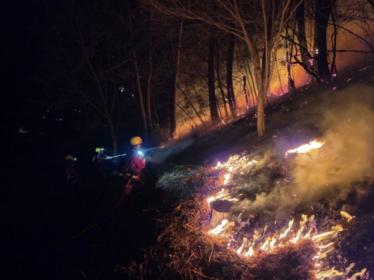
The 'monster wildfire' that has been ongoing for a week continues to spread to an extent that damage assessment is impossible. There are even concerns about a 'perfect storm' where multiple disasters combine into an uncontrollable catastrophe.
According to the Central Disaster and Safety Countermeasures Headquarters on the 27th, as of 5 a.m., the death toll from wildfires in the Gyeongbuk and Gyeongnam regions reached 26. This is the largest damage ever recorded. Twenty-two people were killed by the fire that started in Uiseong, and four died in the wildfire in Sancheong, Gyeongnam. A total of 317 buildings were destroyed, and the number of evacuated residents reached 22,406. The problem is that it does not stop there. The wildfire's momentum is threatening Busan's Gijang and Ulju, where nuclear power plants are located, the East Coast, and Cheonwangbong Peak of Jirisan. The rain on the 27th is far from sufficient for firefighting.
Wildfire Turns into a Disaster, Breaking All Previous Damage Records
The wildfires ignited in Sancheong, Gyeongnam, and Uiseong, Gyeongbuk, have spread to almost the entire inland mountainous area of Gyeongbuk and a significant part of Gyeongnam, breaking all previous wildfire damage records. In Gyeongbuk alone, the affected area is 33,204 hectares, surpassing the previous record set by the 2000 Gangwon Goseong East Coast wildfire. The East Coast wildfire, which even melted the bronze bell of the thousand-year-old Naksansa Temple, lasted for over a month. However, this wildfire has exceeded the East Coast wildfire's affected area in just one week. Including the affected areas of wildfires in Gyeongnam and Ulsan, the total reaches 35,810 hectares?an area equivalent to over 51,000 soccer fields combined.
The human toll is even more severe. The 26 confirmed deaths so far are the highest number of wildfire disaster fatalities since the Korea Forest Service began wildfire statistics in 1987, tied with the 1989 wildfire. The fatalities in Gyeongbuk include 1 in Uiseong, 4 in Andong, 3 in Cheongsong, 6 in Yeongyang, and 8 in Yeongdeok. Essentially, the inland areas of Gyeongbuk and the affected regions of Gyeongnam are all facing life-threatening situations due to the wildfires.
Moreover, the Ulju Onyang wildfire began moving southward from the afternoon of the 26th, starting to threaten Busan. The wildfire spread to Yangsan City in Gyeongnam, which borders Ulju County, prompting evacuation orders, and cultural heritage within Jangansa Temple in Gijang County, Busan, was urgently relocated. The Gyeongbuk Northern Second Prison in Cheongsong and Andong Prison evacuated inmates to safe zones urgently. Major roads, including the Seosan-Yeongdeok Expressway, were even closed.
There are concerns that the Uiseong wildfire could spread to Gangwon Province via Uljin and Pohang. The wildfire that started in Uiseong has spread eastward to Andong, Cheongsong, Yeongyang, Yeongdeok, and up to the Uljin border. The phenomenon of embers scattering and igniting new fires, known as 'spot fires,' could cause the flames to spread to the Gangwon region.
The wildfire in Sancheong, Gyeongnam, which has not subsided for six days, has spread to Jirisan National Park. Jirisan National Park, Korea's first national park designated in 1967, spans three provinces: Gyeongnam (Sancheong, Hadong, Hamyang), Jeonnam (Gurye), and Jeonbuk (Namwon), covering an area of 483 square kilometers. On the afternoon of the 26th, the wildfire crossed the Gugoksan ridge adjacent to Jirisan and spread inside the park's boundary. The affected area in the Jirisan region is estimated to be about 20 hectares. The Juwangsan National Park in Cheongsong has already suffered significant forest loss.

Warzone-like Damage Areas, Evacuations Amid Chaos
Many of the deceased died from suffocation due to wildfire smoke or during evacuation. In Samui-ri, Seokbo-myeon, Yeongyang County, Gyeongbuk, a village chief and his spouse died while trying to evacuate residents. They apparently headed in the opposite direction of the evacuation site, Seokbo Elementary School, and could not escape the flames and smoke.
In Yeongdeok-eup, Yeongdeok County, Gyeongbuk, on the night of the 25th, three people in their 80s died when a nursing home vehicle evacuating residents from the fireball exploded. Less than ten minutes after the vehicle entered National Route 7, embers flew in from all directions, eventually causing the vehicle to explode. An elderly man in his 80s also died in a house destroyed by the wildfire in Andong; he was unable to evacuate due to mobility issues.
Most of the deceased are elderly people in their 60s to 80s living in rural or mountainous areas. They stayed behind to protect their homes but were engulfed by flames and smoke. Due to mobility difficulties and challenges in timely receiving disaster safety alerts, they suffered fatal consequences. The affected areas lack major roads or have winding forest roads, making rapid evacuation difficult. A firefighting helicopter from Inje County, Gangwon Province, crashed in Uiseong, resulting in the pilot's death.

Wildfire Suppression Rate Declines, Future Uncertain
The suppression rate has also declined. According to the government, as of 5 a.m. on the 27th, the remaining fire line in Gyeongbuk is 355.4 kilometers, with a suppression rate of 44.3%. This is a significant drop from 68% on the 26th. The Sancheong-Hadong wildfire had a suppression rate of 80% at 9 a.m. on the 26th but remained stagnant at 77% by 9 p.m. the same day.
The suppression rate for the Ulju Onyang wildfire in Ulsan was 92% on the morning of the 26th but fell to 76% on the 27th. Over 100 helicopters and more than 1,000 firefighting personnel from various regions are engaged in firefighting efforts, but the flames remain difficult to control. Ultimately, the wind is the problem. For the wildfire spread to subside, strong winds must calm down. However, localized gusts and other wind events continue to be forecasted. The situation remains uncertain.
Aside from the major wildfire-affected areas, new wildfires continue to occur. On the afternoon of the 26th, a wildfire broke out on Hambaksan Mountain in Dalseong County, Daegu, and another wildfire occurred in a mountain area in Muju, Jeonbuk.
© The Asia Business Daily(www.asiae.co.kr). All rights reserved.


