Implementing a Virtual City to Solve Urban Issues
Lee: "We Will Enhance Administrative Efficiency with Digital Twin"
Yongin City in Gyeonggi Province has established a '3D Digital Twin Data Set' across the entire city to efficiently address urban issues.
On the 14th, Yongin City announced that it has expanded the 3D Digital Twin Data Set, which was piloted last year in the areas around the Gyeongbu and Yeongdong Expressways in Giheung-gu and Suji-gu, to cover the entire city area of 591.5㎢.
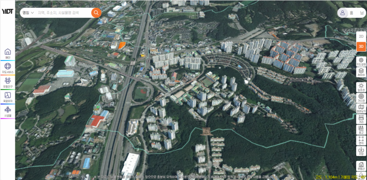 Yongin City is the first basic local government to establish a '3D Digital Twin Data Set' across the entire city. Provided by Yongin City
'Digital Twin' is a technology that replicates real-world spaces in a virtual environment to help predict and respond to future scenarios. In the field of national land information, it can be used to virtually recreate the current state of a city to monitor, diagnose, predict, and derive solutions for various potential problems. Countries such as the United States, Singapore, and the United Kingdom have introduced and actively utilized this technology as an alternative to predict future environments and solve urban issues.
Among metropolitan governments, Seoul City has previously established a 3D Digital Twin Data Set for the entire city, and Yongin City is the first among basic local governments to do so.
Earlier, in 2023, Yongin City was selected for the Ministry of Land, Infrastructure and Transport's 'Digital Twin National Land Pilot Project' and built a 3D data set based on digital twin technology over approximately 37.4㎢ around the Gyeongbu and Yeongdong Expressways.
Through the 3D Digital Twin Data Set, the city has constructed large-scale spatial data including ▲multi-directional aerial oblique camera and aerial laser sensor imaging data ▲3D building model production ▲digital elevation model production ▲realistic orthophoto production.
The constructed data received a suitability certification in December last year from the Public Survey Quality Management Institute's public surveying performance review, and since last month, it has been utilized for facility management of national and public lands, overpasses, and bridges. The city plans to further support urban planning review tasks by implementing functions such as visibility and view analysis, 3D perspective views, and developing flood prediction models.
Lee Sang-il, Mayor of Yongin City, stated, "We will efficiently provide administrative services essential to citizens by utilizing the 3D Digital Twin Data Set established across the entire city."
© The Asia Business Daily(www.asiae.co.kr). All rights reserved.


