Selected for Two Consecutive Years, Securing 2 Billion KRW in National Funding
Completing Digital Twin Ulsan... Laying the Foundation for Urban Data
Ulsan City has been selected for the Ministry of Land, Infrastructure and Transport’s “2025 Digital Twin Early Completion National Fund Matching High-Precision Electronic Map Construction Challenge Project,” securing 2 billion KRW in national funding.
The high-precision electronic map construction project is part of a national agenda to create large-scale digital topographic maps (1:1000 digital topographic maps) necessary for data-driven administrative tasks and private sector use, and to build essential 3D spatial information of urban areas for digital twin operations.
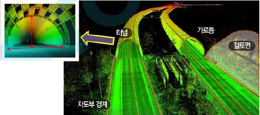 High-precision road map. 3D road registry (streetlights, roadside trees, traffic lights, signboards, etc.), core infrastructure for autonomous driving, IoT-based traffic facility management. Provided by Ulsan City
The “large-scale (1/1000) digital topographic map” includes detailed urban infrastructure elements such as manholes, streetlights, and traffic signals, which were difficult to represent on the existing 1/5000 digital topographic maps.
It plays a crucial role as basic data for urban planning, social overhead capital (SOC) design, and underground facility management, and enables rapid and accurate response during emergencies.
Additionally, it is utilized in various location-based services such as domestic and international map portal services, navigation, and site analysis, providing citizens with accurate and detailed geographic information.
With this selection, Ulsan City plans to invest a total of 4 billion KRW by December to produce digital topographic maps based on aerial photographs for the Taehwagang area and approximately 199㎢ of development-restricted zones.
In particular, by utilizing aerial drones, LiDAR, and Mobile Mapping Systems (MMS), the city will establish basic spatial information such as ecological river terrain maps of Taehwagang, detailed road maps, and 3D models of buildings and trees, laying a data foundation for administrative and private sector use in climate crisis response, urban flood prediction, autonomous driving, and more.
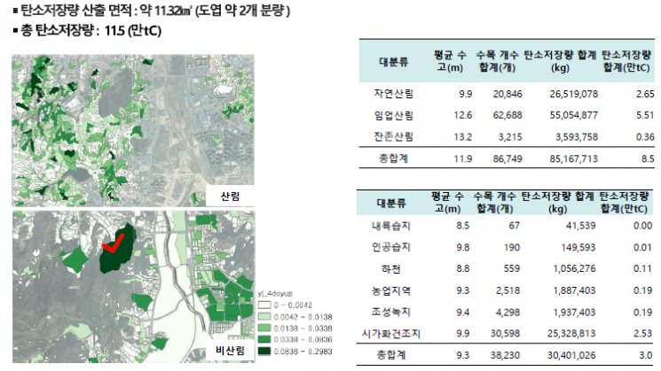 Establishment of Carbon Storage Database Based on Urban Ecological Status Map Using Airborne LiDAR, Hyperspectral, and Satellite Images, and Forest Digital Map. Provided by Ulsan City
An official from Ulsan City stated, “Being selected for this project two years in a row has laid the foundation for realizing Digital Twin Ulsan,” adding, “We will make every effort to promote the project so that the convergence and fusion of spatial information technology can improve citizens’ convenience and the quality of administrative services.”
Last year, Ulsan City was also selected for this project and is currently producing digital topographic maps for approximately 183㎢ of development-restricted zones and major development sites with a project budget of 3.5 billion KRW. The city plans to complete the latest digital topographic maps covering the entire Ulsan area by 2026.
© The Asia Business Daily(www.asiae.co.kr). All rights reserved.


