The agricultural and forestry satellite will be launched into space next year. Once the agricultural and forestry satellite is positioned in space, it is expected to lay the foundation for directly observing and responding to changes in forest ecosystems and forest disaster situations such as wildfires from space.
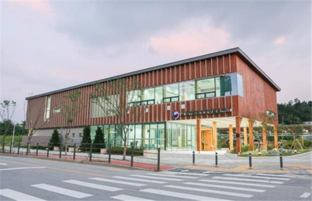 Exterior view of the 'National Forest Satellite Information Utilization Center.' The Forest Satellite Center will open on the 9th of next month in Godeok Biz Valley, Gangdong-gu, Seoul. Provided by the National Institute of Forest Science
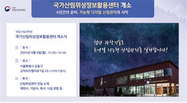
◆ Establishment of a dedicated agency and systematization of agricultural and forestry satellite utilization = The National Institute of Forest Science announced on the 28th that it will open the "National Forest Satellite Information Utilization Center" (hereinafter referred to as the Forest Satellite Center) on the 9th of next month.
The Forest Satellite Center is newly established as a dedicated agency to utilize agricultural and forestry satellite information. The purpose of operating the Forest Satellite Center is to build a precise digital forest management system by converging information collected by the agricultural and forestry satellite with big data on forest environments using advanced artificial intelligence technology.
The Forest Satellite Center plans to establish an integrated ground station system before the launch of the agricultural and forestry satellite next year and complete linkage tests with the National Satellite Operation Center of the Korea Aerospace Agency.
Following this, after the launch of the agricultural and forestry satellite, the center will go through a pre-inspection phase of the service system for the outputs, aiming to provide actual services from the first half of 2026, according to the schedule planned by the Forest Science Institute.
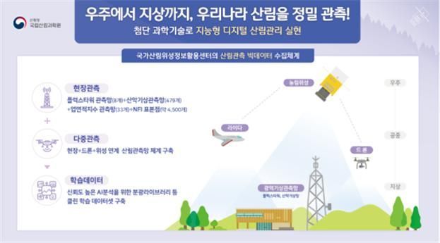
After the agricultural and forestry satellite is positioned in space, the National Satellite Operation Center will generate basic calibrated data by assigning location information to raw images, and the Forest Satellite Center, which receives this data, will take on the role of precise calibration, analysis preparation, and sequential production of 27 types of converged data. The converged data includes 6 types of forest disasters, 9 types of forest ecology and health, and 12 types of forest resources and statistics.
◆ Agricultural and forestry satellite launch enables seamless forest management = The agricultural and forestry satellite functions as a kind of CCTV overlooking the Korean Peninsula from space. It monitors large-scale forest disasters and comprehensively observes forest changes across the entire Korean Peninsula.
In particular, the high-resolution optical sensor equipped on the agricultural and forestry satellite is optimized for 5-meter resolution and plant vitality analysis, making it possible to observe forest conditions ‘wider, faster, and more accurately’ than existing satellites, including distinguishing between coniferous and broadleaf trees even from space.
The agricultural and forestry satellite is also the first domestic optical satellite capable of capturing a 120 km-wide area in a single shot. This is 1.6 times wider than the coverage of the U.S. satellite RapidEye (77 km), allowing the entire Korean Peninsula to be photographed within three days, the Forest Science Institute explained.
Especially, by equipping the red edge (RE) and near-infrared (NIR) bands, which are highly sensitive to plant vitality, it has the advantage of more accurately analyzing forest changes.
The Forest Science Institute plans to establish a precise digital forest management foundation that densely monitors the Korean Peninsula’s forests ‘from space to ground’ by utilizing data obtained from the agricultural and forestry satellite and its own wide-area ground observation network accumulated over more than 10 years. The wide-area ground observation network includes 8 flux towers, 479 mountain weather observation stations, and 33 leaf area index observation stations.
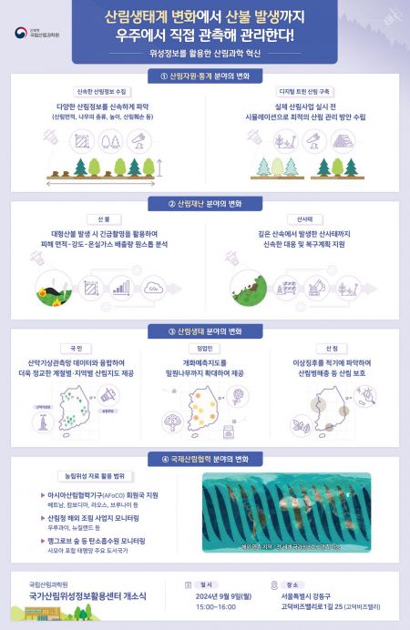
◆ The ‘digital forest management era’ launched by the agricultural and forestry satellite = The digital forest management era opened by the launch of the agricultural and forestry satellite raises expectations for ▲ digital precision forest management ▲ rapid identification and strengthened response to forest disasters ▲ detection of abnormal forest phenomena and precise prediction of flowering and autumn foliage ▲ expansion of international forest cooperation.
The Forest Science Institute expects that the agricultural and forestry satellite, using a full survey method that can photograph the entire Korean Peninsula in three days, will contribute to the rapid identification of various forest information such as tree species, height, volume, forest area, forest damage, and carbon storage. This is expected to overcome the limitations of the existing labor-intensive forest resource survey methods (reliant on field surveys) and reduce errors.
Above all, by utilizing satellite data to build a virtual ‘digital twin forest’ that replicates the real forest, it will be possible to simulate the effects and changes of forest management before implementing forest projects, thereby finding and establishing optimal forest management plans, the Forest Science Institute anticipates.
In the digital forest management era, strengthening forest disaster response through ‘one-stop analysis’ can also be promoted. When forest disasters such as wildfires or landslides occur, the satellite’s imaging direction can be urgently changed to immediately capture the affected area, enabling active response to on-site situations related to forest disasters.
For example, in the event of a large wildfire, the Forest Science Institute plans to support rapid on-site response strategy formulation by instantly assessing the wildfire spread situation, including the area of damage, damage intensity, and greenhouse gas emissions caused by the wildfire, all through one-stop analysis.
Detection of abnormal forest phenomena and precise prediction of flowering and autumn foliage due to climate change will also become possible. The agricultural and forestry satellite is the first domestic satellite equipped with red edge and near-infrared bands sensitive to vegetation vitality, enabling diagnosis of forest growth stress nationwide every 10 to 15 days. This is expected to serve as a basis for early detection of abnormal signs in forest ecosystems caused by climate change and effective response to protect forest ecosystems.
Additionally, the agricultural and forestry satellite has the advantage of being able to capture over 95% of the territories of Vietnam, Cambodia, Laos, and Brunei among the member countries of the Asian Forest Cooperation Organization (AFoCO), and 99% of Uruguay and New Zealand, where the Korea Forest Service conducts overseas afforestation projects. It also enables monitoring of carbon sinks such as mangrove forests along the coasts of major Pacific island countries including Samoa, a target country for international forest cooperation by the Korea Forest Service, thus raising expectations for new progress in international cooperation using agricultural and forestry satellite data.
Baek Jae-su, director of the National Institute of Forest Science, emphasized, “The Forest Satellite Center will be a future growth engine for forest science and a ‘game changer’ leading the digital forest management era not only in Korea but also in the international community.”
Meanwhile, the Forest Satellite Center will open in Godeok Biz Valley, Gangdong-gu, Seoul. The building is the first public wooden structure in Korea built in 2022 using pine trees damaged by the Gyeongbuk and Gangwon wildfires, symbolically demonstrating the utilization of wildfire-damaged timber.
Above all, due to the characteristics of wooden architecture, the Forest Satellite Center building stores 30 tons of carbon. This amount is equivalent to the carbon emissions of 74 top energy efficiency grade 1 cars over one year. A total of 134 cubic meters of wood was used in the building, with over 73% of the wood being domestically sourced.
© The Asia Business Daily(www.asiae.co.kr). All rights reserved.


