Power Gradually Weakening
Strong Rain and Wind Expected Until the 21st
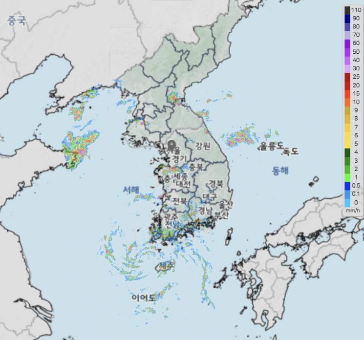
The 9th typhoon of the season, 'Jongdari', is moving northward along the west coast, bringing heavy rain mainly in the strong wind zone.
According to the Korea Meteorological Administration, as of 5 p.m. on the 20th, Jongdari is moving north at a speed of 33 km/h about 100 km west of Seogwipo. A typhoon advisory has been issued for Jeju Island.
The maximum wind speed is 18 m/s, and the central pressure is 1000 hPa (hectopascal), slightly exceeding the typhoon criteria (tropical cyclone with a maximum central wind speed of 17 m/s or more).
Currently, the sea surface temperature in the West Sea is around 29 degrees Celsius, higher than usual, but since the water is shallow, the heat capacity is not sufficient for Jongdari to strengthen as it passes. Therefore, Jongdari is expected to gradually weaken as it moves northward.
Jongdari will move closely along the west coast, causing friction with the land, which will also contribute to weakening its strength.
Jongdari is expected to weaken into a tropical depression between late night on the 20th and early morning on the 21st.
After weakening into a tropical depression, Jongdari will turn northeast and make landfall northwest of Seosan, Chungnam, on the morning of the 21st, then pass through the central region.
From the afternoon of the 20th to the morning of the 21st, when Jongdari is moving north along the west coast, heavy rain will pour in Jeju and Honam regions within the typhoon's strong wind zone, as well as in the southern coast and near Jirisan where the southeasterly wind blowing between the typhoon and the North Pacific High collides with the terrain.
After Jongdari changes into a tropical depression and passes through the central region, heavy rain will fall strongly in southern Gyeonggi and Chungcheong on the 21st from early morning to daytime.
From morning to afternoon on the 21st, rainfall of 30 to 50 mm per hour is expected in the inland and mountainous areas of Gangwon, and around 30 mm per hour in other parts of Gangwon. Jongdari is expected to weaken into a tropical depression and change direction as it passes through the central region on the 21st, bringing heavy rain to the central region as well.
Due to the hot and humid southeasterly winds blowing between Jongdari and the North Pacific High, some areas have already experienced rain since the morning of the 20th. In Ulsan, some places recorded over 100 mm of rain that morning.
From now until the 21st, 30 to 80 mm of additional rain is expected nationwide (20 to 60 mm in the West Sea Five Islands, 10 to 40 mm on the east coast of Gangwon).
However, areas with heavy rainfall exceeding 100 mm may include the mountainous regions of Jeju, near Jirisan, the west and south coasts, northern inland Chungnam, central-northern Chungbuk, southern Gyeonggi, and inland and mountainous areas of Gangwon.
Jeju will continue to experience strong winds with maximum instantaneous wind speeds of 70 to 110 km/h (20 to 30 m/s), so precautions against rain and wind are necessary.
On the eastern coast of Jeonnam and the southern coast of Gyeongnam, winds will be strong enough to reach instantaneous wind speeds of 55 to 70 km/h (15 to 20 m/s). Additionally, from night on the same day, strong winds with instantaneous wind speeds around 55 km/h (15 m/s) are expected on the central west coast and in Busan.
© The Asia Business Daily(www.asiae.co.kr). All rights reserved.


