Materials Created by Japan During Tsunami Warning
Ministry of the Interior and Safety Deletes Them Late... "Careful Review"
The Ministry of the Interior and Safety used a map showing Dokdo as Japanese territory in the civil defense cyber education video materials and later removed it belatedly.
According to the government on the 10th, the Ministry commissioned and produced the 2025 civil defense cyber education video materials from three companies. Among them, one company's materials included a segment explaining earthquake response measures using a broadcast video from the United States, in which the attached map depicted Dokdo as Japanese territory.
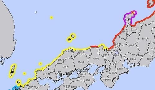
The problematic map in the video was from data released by the Japan Meteorological Agency when a magnitude 7.6 earthquake occurred in the Noto region of Ishikawa Prefecture, Japan, on January 1 of this year. At that time, the Japanese data included Dokdo in the tsunami advisory area as if it were their territory, which caused controversy, and our Ministry of Foreign Affairs lodged a stern protest regarding this.
After this fact became known through media reports, the Ministry of the Interior and Safety took belated deletion measures. The Ministry stated, "Despite prior review, inappropriate materials were used in the educational video, so we immediately deleted them and replaced them with other educational videos," and added, "We will conduct more careful reviews of materials used in civil defense educational videos in the future."
© The Asia Business Daily(www.asiae.co.kr). All rights reserved.


