Production of Marine Debris Distribution Map... Large Aquaculture Farm Waste Materials as Major Causes
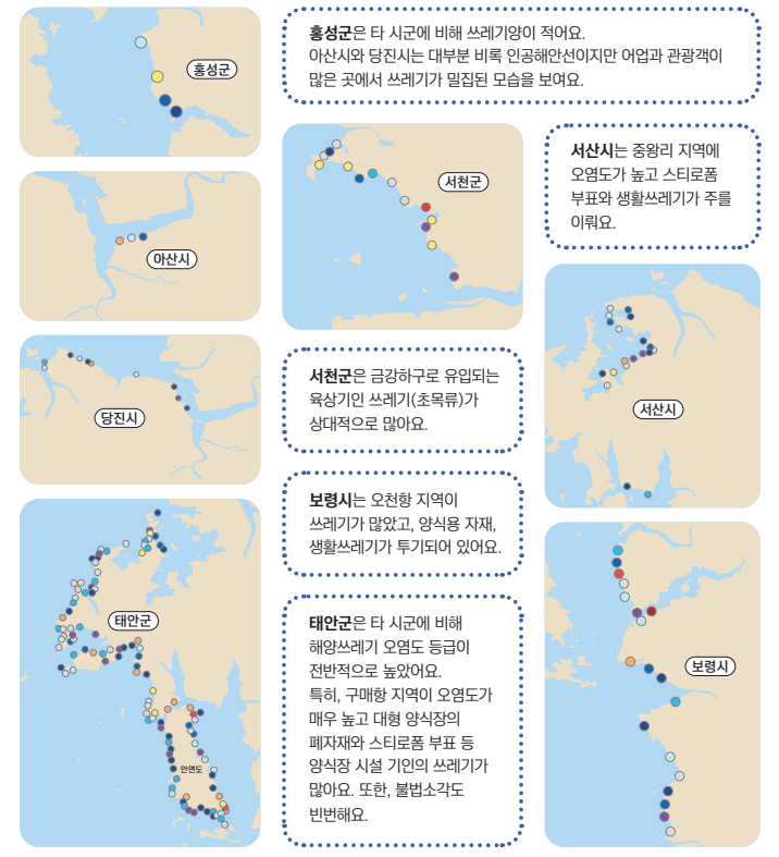
The level of marine debris pollution in Taean-gun, Chungnam Province, was found to be generally high.
Chungnam Province is conducting the nation's first survey that categorizes the distribution status of marine debris into island, coastal, and submerged debris. The Chungnam Research Institute released a marine debris distribution map containing this information on the 18th.
The map displays pollution levels divided into 10 grades, from level 0 to 9, according to the distribution of marine debris.
Taean-gun showed generally higher marine debris pollution compared to other cities and counties. In particular, the Gumaehang area in Taean has the highest pollution, with large aquaculture farm waste materials and styrofoam buoys from aquaculture facilities identified as the main causes.
Seosan City showed high pollution in the inner area of Garorim Bay, and Boryeong City had high pollution in the Ocheon Port area. Seocheon-gun was found to have a large amount of debris flowing into the Geum River estuary.
The research institute plans to establish a systematic collection and management system based on the distribution map.
An institute official stated, "Coastal areas on the mainland have more active coastal cleanup activities compared to island areas, but the timing of debris removal is inconsistent, leading to insufficient management. Through the creation of this map, we aim to establish a management foundation to make the sea cleaner."
© The Asia Business Daily(www.asiae.co.kr). All rights reserved.
![Clutching a Stolen Dior Bag, Saying "I Hate Being Poor but Real"... The Grotesque Con of a "Human Knockoff" [Slate]](https://cwcontent.asiae.co.kr/asiaresize/183/2026021902243444107_1771435474.jpg)


