Starting this month, the indoor navigation system 'GoterMap' will be fully operational in the underground shopping area of Express Bus Terminal Station... Road name addresses and location information devices installed for 630 roads and stores inside the Express Bus Terminal underground shopping area... ▲Fast route guidance ▲Navigation ▲Augmented Reality (AR) mode ▲Category search and other indoor navigation services provided
Seocho-gu, Seoul (Mayor Jeon Seong-su) has started operating an indoor navigation service called ‘GoterMap’ from this month to help visitors easily find their desired destinations in the maze-like underground shopping area of Express Bus Terminal Station.
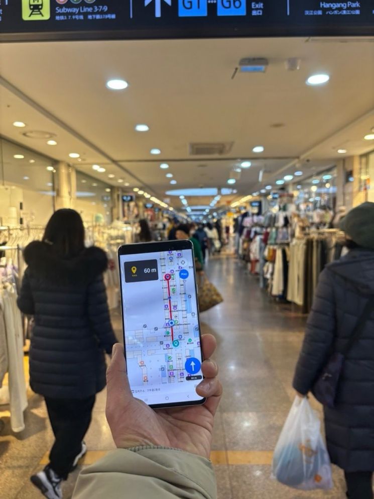
‘GoterMap’ is a smart administrative service model that assigns road names and basic numbers to each store to build spatial data information, implementing navigation through an app to provide location information.
The service area covers a total of 31,566㎡ around the Gotomall in the underground shopping area of Express Bus Terminal Station. This area houses about 630 stores densely packed within a complex indoor structure, which has often caused confusion among visitors. Merchants have also continuously voiced these difficulties.
While promoting the establishment of indoor navigation, the district subdivided the addresses in this space for easier understanding. Road names and basic numbers were assigned to the internal roads and stores of the Express Bus Terminal underground passage, which previously had only one road name. Address information facilities such as building number plates and object address plates were installed. Additionally, about 150 Bluetooth-based location information transmission devices were installed throughout the area.
Based on this, the ‘GoterMap’ app provides easy and diverse indoor navigation services for Gotomall, with main features including ▲Quick Route Guidance ▲Route Navigation ▲Augmented Reality (AR) Mode ▲Category Search.
‘Quick Route Guidance’ directs users to the nearest exit and restroom from their current location, enabling swift movement in emergencies or urgent situations. ‘Route Navigation’ guides users to their searched destination, displaying the remaining time and distance along with voice instructions.
Also, the ‘Augmented Reality (AR) Mode’ shows store information when the app recognizes nearby stores through the phone’s camera. ‘Category Search’ classifies facilities such as exits, restrooms, restaurants, shopping, and convenience facilities to help users easily find what they need.
In addition, the app offers English guidance for foreign tourists, a simulation driving feature to preview routes, and local weather information.
The district expects this service to improve convenience and accessibility for visitors to the Express Bus Terminal, and to help prevent safety accidents by enabling quick location of exits or emergency exits during fires or other disasters and emergencies.
The ‘GoterMap’ app can be downloaded from the Google Play Store, and an iPhone version will be released later.
Previously, in February last year, the district was selected in the Ministry of the Interior and Safety’s pilot project for ‘Address Information Advancement and Address-Based Innovation Industry Creation’ in the field of indoor navigation implementation. With 200 million KRW in national funding, a service contract was carried out for seven months starting June last year.
Going forward, the district plans to improve the service after conducting satisfaction surveys and expand it to the entire area around Express Bus Terminal Station. Additionally, maps using the three-dimensional addresses assigned to the internal roads and stores of the underground shopping area will be created and provided to fire and police stations to aid in preventing safety accidents.
Meanwhile, the district is promoting the designation of the ‘Goter·Sebit Tourist Special Zone’ from the Express Bus Terminal area to Banpo Hangang Park, expecting that the introduction of GoterMap will also be effective in attracting domestic and international tourists.
Seocho-gu Mayor Jeon Seong-su said, "We will continue to develop this service so that it helps the convenience and safety of visitors to the Express Bus Terminal area and serves as a good example of indoor spatial information construction.”
© The Asia Business Daily(www.asiae.co.kr). All rights reserved.


