The newly designated candidate sites for residential land share the common characteristics of excellent locations such as railway station areas and high-tech industrial complexes, or regions where housing supply has been insufficient compared to demand. The government plans to propose differentiated development directions for each district in consultation with local governments, considering local demand and location characteristics, and to implement transportation measures linked to railway stations and major roads to create cities with convenient transportation.
Osan Segyo 3 and Yongin Idong, Semiconductor-Specialized 'Self-Sufficient Connect and High-Tech City'
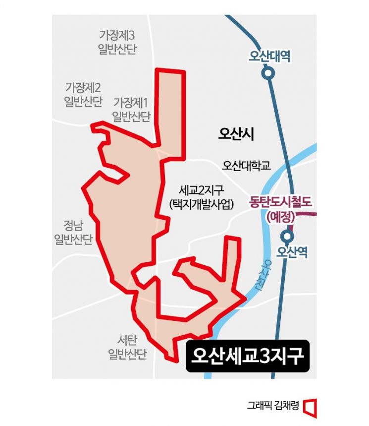
The Osan Segyo 3 district covers 4.33 million square meters (1.31 million pyeong) in the areas of Gasu-dong, Gajang-dong, Gwoldong, Geumam-dong, Nueup-dong, Dugok-dong, Beoreum-dong, Seodong, and Tap-dong in Osan-si, Gyeonggi-do, designated as a new candidate site for residential land. The government plans to supply 31,000 housing units here. Osan Segyo 3 is located at the center of the Hwaseong, Yongin, Pyeongtaek semiconductor cluster and has excellent accessibility to Seoul via railway transportation such as the Suwon-origin KTX (opening in 2025) and GTX-C extension, leading to increasing residential demand. The government will establish a 'self-sufficient Connect City' by installing complex community facilities accessible to all in the area adjacent to Segyo 1 and 2 districts. Additionally, it will expand public transportation networks with 10-minute access to major railway transportation hubs such as Osan Station (KTX, GTX-C) and Dongtan Station (SRT, GTX-A), significantly improving accessibility to major centers like Seoul Gangnam, Suwon, and Dongtan.
The Yongin Idong district will be developed as a semiconductor-specialized city. Yongin Idong is adjacent to the Yongin High-Tech Semiconductor National Industrial Complex and Yongin Techno Valley (Phases 1 and 2), with the Yongin Semiconductor Cluster General Industrial Complex (14.5 km) located to the east. With numerous high-tech industries, there is an urgent need to create a hinterland city to meet the housing demand of IT talents. Accordingly, the government has designated the areas of Deokseong-ri, Cheolli, Muk-ri, and Sami-ri in Idong-eup, Cheoin-gu, Yongin-si, Gyeonggi-do as a new candidate site, planning to supply 16,000 housing units over 2.28 million square meters (690,000 pyeong). The government plans to significantly enhance living infrastructure and services for residents and develop the area into a 'Work·Live·Play High-Tech City' applying advanced smart city technologies. Furthermore, it will expand east-west road transportation networks connecting the site with Dongtan Station (SRT, GTX-A), Yongin High-Tech Semiconductor National Industrial Complex, and SK Hynix Yongin Semiconductor Cluster, as well as north-south road networks linking Yongin city center to the Yongin High-Tech Semiconductor National Industrial Complex, and strengthen connectivity with the Sejong-Pocheon Expressway.
Guri Topyeong 2, Han River View Specialized 'Riverfront City'
The Guri Topyeong 2 district will utilize its advantageous location along the Han River to develop a residential complex specialized in Han River views, called 'Riverfront City.' In particular, the Han River area will be designated as a specialized zone for views and urban design to create a world-class urban landscape. Covering 2.92 million square meters (880,000 pyeong) in the areas of Gyomun-dong, Sutaek-dong, Acheon-dong, and Topyeong-dong in Guri-si, Gyeonggi-do, the government plans to supply 18,500 housing units. Guri Topyeong 2 is close to the eastern part of Seoul, with the Han River to the south, Achasan Mountain to the west, and adjacent to the northern urban centers of Guri Topyeong and Guri Gyomun. Due to its proximity to Seoul and location along the Han River, it is a highly desirable residential area with strong housing demand from residents of the Seoul metropolitan area.
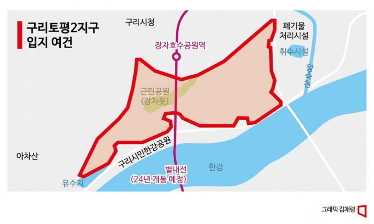
The government plans to improve railway transportation accessibility through internal and external circulation plans connecting Sangbong Line (Line 7, GTX-B), Mangu Station (Gyeongui-Jungang Line), and Jangja Lake Park Station (Byeollae Line). It will also improve the Namguri IC connection facilities on Gangbyeonbuk-ro to Sejong-Pocheon Expressway and prepare plans to expand east-west transportation networks connecting Seoul (Cheongnyangni), the site, and Namyangju to disperse traffic on Gangbyeonbuk-ro.
In Cheongju and Jeju, where housing supply is insufficient... Creating pedestrian-friendly and eco-friendly cities
The Cheongju Bunpyeong 2 district encompasses Bunpyeong, Jangseong, and Jangam-dong in Seowon-gu, and Bangseo and Pyeongchon-dong in Sangdang-gu, Cheongju-si, Chungbuk. It covers a total area of 1.3 million square meters and plans to accommodate 9,000 households. This area is currently expanding its living zone and is adjacent to the Musimcheon and Mipyeongcheon streams. The government plans to establish self-sufficient facilities here to link and complement industrial functions of industrial complexes and install service facilities such as commercial, MICE (Meetings, Incentives, Conferences, and Exhibitions), and community centers to create a complex living space that coexists and develops with the old downtown. The entire district aims to be a pedestrian-friendly city with a continuous walking path and a 10-minute walkable city. To improve metropolitan transportation accessibility, new public transportation networks connecting Cheongju International Airport and Osong Station will be established, and intercity bus transfer centers and connecting roads near the district will be expanded.
The Jeju Hwabuk 2 district spans Doryeonil, Hwabuk-i, and Yeongpyeong-dong in Jeju-si, covering a total area of 290,000 square meters. The government plans to supply 5,500 housing units here. Jeju faces a shortage of existing public housing supply compared to its growing population, and while development is active in the western region (such as Yeondong), the eastern region requires planned development to revitalize it. Accordingly, the government intends to transform Jeju Hwabuk 2 into a representative residential complex in the eastern region by allocating knowledge and high-tech industries, commercial, and social infrastructure (SOC) functions. Additionally, it will convert renewable energy sources such as solar and wind power into hydrogen fuel for urban energy use, expand hydrogen charging stations and hydrogen vehicle distribution, and develop the area as a 'Green Hydrogen Energy City' serving as a testbed for eco-friendly energy.
All newly designated residential land districts will be developed in connection with nearby existing downtowns, residential districts, and industrial areas to complement and share the previously insufficient urban functions and infrastructure, forming integrated self-sufficient living zones. To create nature-friendly cities that coexist with the environment, the government plans to secure about 30% of the district area as parks and green spaces and establish linear parks connecting waterfront spaces and green areas within walking distance. To develop 'child-friendly cities,' childcare facilities such as daycare centers and child care centers, cultural facilities like libraries, hospitals, academies, and cafes will be gathered in one place to form 'child care clusters.' Furthermore, to ensure all districts become cities with convenient transportation, new roads and public transportation routes will be established and finalized, significantly improving transportation conditions.
© The Asia Business Daily(www.asiae.co.kr). All rights reserved.


