East Wind Heats Up Crossing Taebaek Mountains, Bringing Late Summer Heat
Daytime Temperatures Rise West of Taebaek Mountains, Possible Showers
Last night, an unusual 'tropical night in September' occurred in Seoul, Incheon, and other areas. The east wind blowing onto the Korean Peninsula heated up as it crossed the Taebaek Mountains, causing a late summer heatwave.
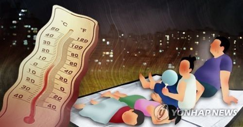
According to the Korea Meteorological Administration on the 5th, the nighttime minimum temperatures (from 6 p.m. to 9 a.m. the next day) in regions including Seoul, Incheon, Cheongju, Gunsan, Yeosu, and Jeju Island were above 25 degrees Celsius, resulting in tropical nights. Among these, Incheon, Cheongju, and Gunsan recorded the hottest September nights since observations began.
From the night of the 4th to the morning of the 5th, Seoul's daily minimum temperature reached 25 degrees Celsius. This was the third highest daily minimum temperature ever recorded in September. The occurrence of tropical nights in Seoul during September is an 'unusual phenomenon,' having happened only three times before this date.
This tropical night is analyzed to be caused by the east wind, which warmed as it crossed the Taebaek Mountains after riding the edge of a high-pressure system over China, heating the nighttime air mainly on the western side of the mountain range. This weather pattern is expected to continue for some time.
On the 5th, the western side of the mountain range will remain hot, while the eastern side will be cool.
At 8 a.m. on this day, temperatures in major cities were: Seoul 25.4°C, Incheon 25.9°C, Daejeon 25°C, Gwangju 24.6°C, Daegu 25.5°C, Ulsan 24.7°C, and Busan 26.1°C.
The daytime high temperatures are expected to range from 25 to 32 degrees Celsius.
In the metropolitan area, Chungcheong, Honam, and western Gyeongsang regions, daytime temperatures will rise above 30 degrees Celsius due to the east wind heated by crossing the mountain range, while Gangwon Yeongdong and the eastern coast of Gyeongsang, which face the east wind directly, will see temperatures remain between 25 and 30 degrees Celsius even at midday.
In areas where daytime temperatures rise sharply, atmospheric instability caused by temperature differences between the upper and lower layers of the atmosphere may lead to localized showers. Expected precipitation amounts range from 5 to 40 mm.
From this day, strong winds with instantaneous speeds exceeding 55 km/h (15 m/s) are expected along the coastlines of Gyeongnam, southern Jeonnam, eastern Gyeongbuk, and Jeju. Along the Gyeongnam and eastern Gyeongbuk coasts, instantaneous wind speeds will reach over 70 km/h (20 m/s) from morning and afternoon respectively, requiring caution.
© The Asia Business Daily(www.asiae.co.kr). All rights reserved.
![Clutching a Stolen Dior Bag, Saying "I Hate Being Poor but Real"... The Grotesque Con of a "Human Knockoff" [Slate]](https://cwcontent.asiae.co.kr/asiaresize/183/2026021902243444107_1771435474.jpg)


