Establishment of Improvement Measures Reflecting ‘Traffic Impact’ of Large-Scale Development Projects such as Yongsan Park Creation, International Business District Development, and Hannam Redevelopment Promotion Project Needed
Comprehensive Road Network Plan as the ‘Arteries of the City’... To Be Reflected in Individual Project Traffic Plans
Applicable to Entire Yongsan, Promoting Systematic Urban Development through Proactive Response
Yongsan-gu (District Mayor Park Hee-young) has embarked on establishing a comprehensive traffic system improvement plan considering changes in urban spatial structure. To proactively prepare traffic system improvement measures reflecting the population and traffic volume increases caused by large-scale development projects, a service contract is scheduled to be initiated this month.
Many urban planning experts emphasize that the key factor determining the success or failure of Yongsan development is ‘traffic.’ Despite Yongsan’s optimal location in the heart of Seoul, all traffic axes have been distorted by the Gyeongbu Line railway and the U.S. military base, resulting in a traffic network isolated like an island.
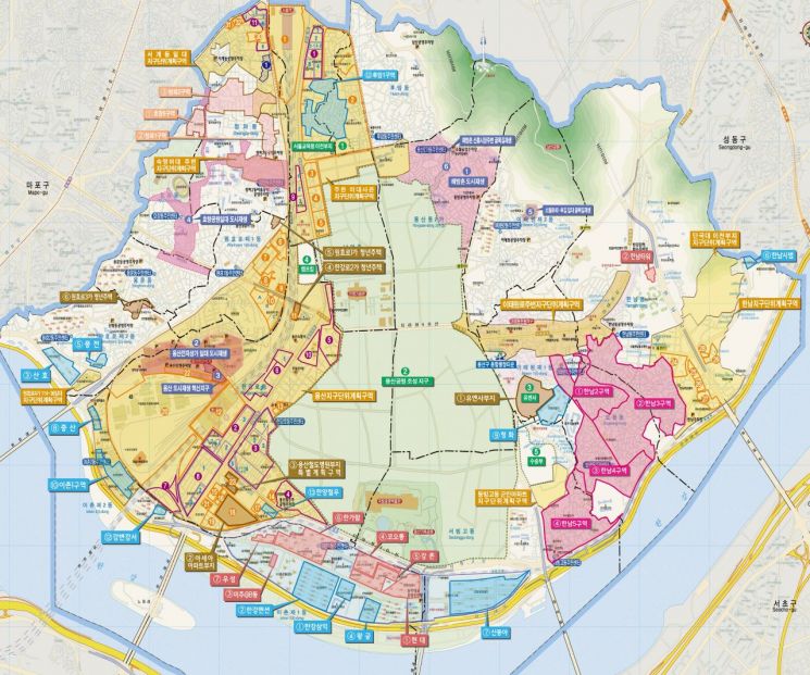
Currently, Yongsan is at the center of significant changes including the creation of Yongsan Park, the International Business District, Yongsan Meta Valley, and the establishment of the National Symbolic Boulevard. Complex developments on sites such as Camp Kim and the Transportation Department, as well as the UN Command site, are underway, along with the construction of youth housing near Wonhyo-ro 3-ga Station. Additionally, redevelopment projects such as Hannam 3 District, scheduled for relocation in October, and Hannam 2, 4, and 5 District Redevelopment Promotion Projects, housing redevelopment in Cheongpa-dong, and apartment remodeling projects in Ichon-dong and Hannam-dong are gaining momentum.
Moreover, various redevelopment and reconstruction projects, apartment remodeling, and redevelopment promotion projects are expected to significantly impact the urban spatial structure.
In particular, these projects induce population growth and commercial area expansion, generating increased traffic demand. If the increased traffic volume is not managed systematically, traffic conditions will inevitably worsen. In the long term, this will reduce regional accessibility and hinder spatial development of the city.
However, the various development projects currently underway throughout Yongsan are implemented by different entities including central government ministries, Seoul City, Yongsan-gu, and private sectors, with widely varying progress statuses.
Furthermore, individual projects only consider traffic impacts on nearby areas, lacking comprehensive review and analysis of traffic impacts reflecting macro traffic flows and regional conditions.
Last October, Seoul City announced plans to create a 7 km ‘National Symbolic Boulevard’ connecting Gwanghwamun Square, Seoul Station, Yongsan, and the Han River. The plan includes significantly reducing lanes, expanding pedestrian paths by 1.5 times, and establishing bicycle lanes.
There is also a growing call to reorganize the road network distorted by the U.S. military base. Itaewon-ro, a major road in the city center, remains only four lanes due to crossing the military base, causing frequent congestion in the Itaewon-ro area. Similarly, Dongjak Bridge, unlike other Han River bridges extending straight to the northern end, has a 90-degree bend at the entrance and exit sections, prompting calls for straightening and other measures.
In response, the district recognizes these issues and is proactively seeking solutions by launching a ‘Comprehensive Traffic System Improvement and Management Plan Considering Changes in Urban Spatial Structure’ project. A bidding announcement for selecting a service provider will be issued by the end of August, with a specialized company to be selected next month to commence the project. The project duration is one year.
This project will focus on predicting traffic demand reflecting spatial structure and development plans, and will review key areas including ▲ traffic improvement measures for various project implementations ▲ strengthening connectivity of urban spatial structures divided by railroads ▲ improving connection systems between arterial roads ▲ and enhancing the functions of Hangang-daero and Noksapyeong-daero.
Based on the project results, an efficient comprehensive traffic system improvement plan will be established and actively coordinated with government ministries, Seoul City, and private sectors to be reflected in overall regional development plans.
Additionally, the plan aims to promote systematic urban development by considering not only internal city road traffic networks but also those connecting to external areas.
Park Hee-young, Mayor of Yongsan-gu, stated, “Traffic planning is not limited to Yongsan-gu but requires macro-level consideration beyond regional boundaries, and it will be too late once various development projects proceed. We will proactively establish a comprehensive traffic system improvement plan to prepare for Yongsan’s new changes.”
© The Asia Business Daily(www.asiae.co.kr). All rights reserved.


