Okinawa Hit Hard, Trees Uprooted
Typhoon 'Khanun' Expected to Land on Korean Peninsula on the 10th
The 6th typhoon, Khanun, has hit Okinawa Prefecture and Kagoshima Prefecture in southern Japan and is moving northward toward the Korean Peninsula.
According to a compilation of reports from Kyodo News, NHK, and Yonhap News on the 8th, Khanun is expected to approach Kyushu in southwestern Japan on the 9th and then move northward toward the Korean Peninsula, making landfall on the southern coast of Korea on the 10th.

The central pressure of the typhoon is 970 hPa (hectopascals), with a maximum wind speed near the center of 30 meters per second. The maximum instantaneous wind speed is 40 meters per second, and strong winds exceeding 25 meters per second are blowing within a radius of 200 km from the center.
The devastation caused by Khanun in Japan provides a rough estimate of the typhoon's intensity. Photos and videos posted by local netizens on social networking services (SNS) show that Okinawa Prefecture is currently experiencing severe damage due to the typhoon.
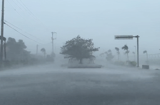
In addition to flooding damage caused by heavy rain, strong winds have blown away and damaged signboards and sculptures. There were even scenes captured of trees uprooted by the wind lying on the streets.
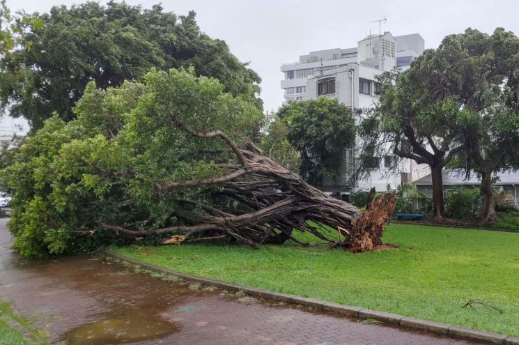 Typhoon No. 6 'Khanun' struck Okinawa, Japan, and on the 2nd, a tree uprooted by strong winds is seen fallen in Naha.
 [Photo by AFP·Yonhap News]
Damage has also occurred in other parts of Japan. Even at Itami Airport (domestic terminal) in Osaka on Honshu, which is relatively far away, flight cancellations and delays occurred. Mazda, an automobile manufacturer, announced that it will temporarily suspend operations at its headquarters and factories in western Honshu, including Hiroshima, on the 9th and 10th.

Due to Khanun's influence, record-breaking heavy rain is expected in the Amami region and southern Kyushu in Japan.

The expected rainfall over 24 hours until 6 p.m. on the 8th is 300 mm in Amami and southern Kyushu, 250 mm in Shikoku, and 200 mm in northern Kyushu. The expected maximum wind speed is 30 meters per second in southern Kyushu and Amami. On the 9th, strong winds of 30 to 40 meters per second are expected in northern Kyushu, and 25 to 29 meters per second in southern Kyushu and Amami.
 A signboard of a building in Naha, Okinawa Prefecture, Japan, fell due to Typhoon Khanun, the 6th typhoon, on the 3rd.
 [Photo by AP·Yonhap News]
Meanwhile, Khanun is blocked by the Pacific high-pressure system and is changing its course northward, passing through Kyushu on the 9th and making landfall on the southern coast of Korea around noon on the 10th, then moving northward across the Korean Peninsula.
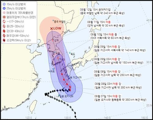 The expected path of Typhoon Khanun No. 6 announced by the Korea Meteorological Administration at 4 PM on the 7th.
 [Photo by Korea Meteorological Administration]
The Korea Meteorological Administration forecasted that the country will come under Khanun's influence starting from the 9th. Khanun is expected to maintain its current 'strong' intensity as it moves northward to the sea 180 km south-southwest of Busan at 3 a.m. on the 10th, then continue moving north-northwest and make landfall in Korea.
© The Asia Business Daily(www.asiae.co.kr). All rights reserved.
![Clutching a Stolen Dior Bag, Saying "I Hate Being Poor but Real"... The Grotesque Con of a "Human Knockoff" [Slate]](https://cwcontent.asiae.co.kr/asiaresize/183/2026021902243444107_1771435474.jpg)


